Miguel Hidalgo geodata
Miguel Hidalgo (Puebla) is a populated place; located in Mexico in America/Mexico_City (GMT-6) time zone. With population of 506 people, there are 16626 cities with bigger population in this country. Compared to other cities in Mexico, 61% of cities are located further ↑North; 69.3% of cities are located further ←West and 89.6% of cities have lower elevation than Miguel Hidalgo. Note1


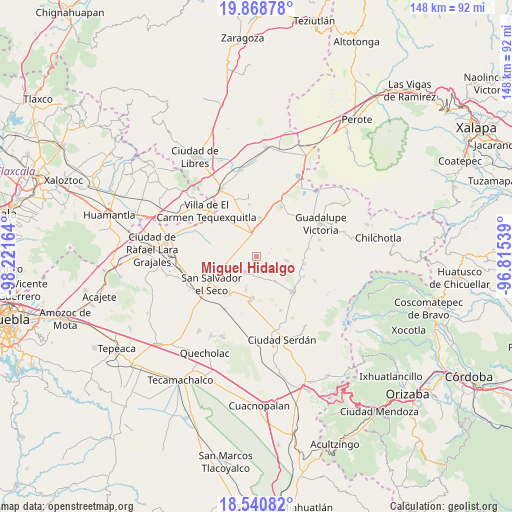
Miguel Hidalgo GPS coordinates[2]
19° 12' 22.104" North, 97° 31' 6.636" West
| Map corner | latitude | longitude |
|---|---|---|
| Upper-left | 19.86878°, | -98.22164° |
| Center: | 19.20614°, | -97.51851° |
| Lower-right: | 18.54082°, | -96.81539° |
| Map W x H: | 147.7×147.7 km | = 91.8×91.8mi |
| max Lat: | 32.7° ⇑61% North |
| Miguel Hidalgo: | 19.20614° |
| min Lat: | ⇓39% South 14.53588° |
| min Long | Miguel Hidalgo | max Long |
| -117.105° | -97.51851° | -86.73105° |
| W 69.3%⇐ | ⇒30.7% E |
Elevation
Elevation of Miguel Hidalgo is 2391 m = 7844 ft, and this is 1137.3 m = 3731 ft above average elevation for this country.
| Max E: |
3497 m = 11473 ft | 10.4% |
| Miguel Hidalgo | 2391 m 7844 ft | |
| Avg. | 1253.7 m = 4113 ft | |
Min E: |
-1 m = -3 ft | 89.6% |
See also: Mexico elevation on elevation.city.
Geographical zone
Miguel Hidalgo is located in North Torrid zone (between Equator and Tropic of Cancer). Distance of this Northern Tropic circle is 470.4 km =292.3 mi to North.| Distance of | km | miles | from Miguel Hidalgo |
|---|---|---|---|
| North Pole | 7871.5 | 4891.1 | to North |
| Arctic Circle | 5265.7 | 3272 | to North |
| Tropic Cancer | 470.4 | 292.3 | to North |
| Equator | 2135.5 | 1326.9 | to South |


Nearby cities:
15 places around Miguel Hidalgo: (largest is in red/bold)
• Aljojuca
11.9 km =7.4 mi,  185°
185°
• Emancipación Quetzalapa
13.8 km =8.6 mi,  105°
105°
• Emilio Portes Gil
11.3 km =7 mi,  4°
4°
• Guadalupe Libertad
13.9 km =8.6 mi,  98°
98°
• José María Morelos
8.9 km =5.5 mi,  143°
143°
• Nuevo Centro de Población Tlachichuca
10 km =6.2 mi,  327°
327°
• San José Barroso
11.1 km =6.9 mi,  260°
260°
• San Juan Atenco
13.5 km =8.4 mi, 189°
• San Miguel Tecuitlapa
9.9 km =6.2 mi,  197°
197°
• San Nicolas Buenos Aires
5.7 km =3.5 mi,  216°
216°
• Santa Cecilia Tepetitlán
9 km =5.6 mi, 99°
• Santa Maria Coatepec
13.3 km =8.3 mi, 215°
• Venustiano Carranza
4.8 km =3 mi,  62°
62°
• Zacatepec
6.9 km =4.3 mi,  347°
347°
• Álamos Tepetitlán
8.5 km =5.3 mi, 97°
Sources, notices
• [Note1] Compared only with cities in Mexico existing in our database
• [Src1] Map data: © OpenStreetMap contributors (CC-BY-SA)
• [Src2] Other city data from geonames.org with taken over terms of usage.
• [Src3] Geographical zone / Annual Mean Temperature by Robert A. Rohde @ Wikipedia
