Aquila geodata
Aquila (Veracruz) is a seat of a second-order administrative division; located in Mexico in America/Mexico_City (GMT-6) time zone. With population of 754 people, there are 11619 cities with bigger population in this country. Compared to other cities in Mexico, 68.8% of cities are located further ↑North; 71.4% of cities are located further ←West and 65.3% of cities have lower elevation than Aquila. Note1


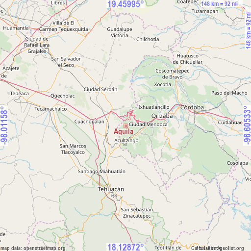
Aquila GPS coordinates[2]
18° 47' 44.34" North, 97° 18' 30.42" West
| Map corner | latitude | longitude |
|---|---|---|
| Upper-left | 19.45995°, | -98.01158° |
| Center: | 18.79565°, | -97.30845° |
| Lower-right: | 18.12872°, | -96.60533° |
| Map W x H: | 148×148 km | = 92×92mi |
| max Lat: | 32.7° ⇑68.8% North |
| Aquila: | 18.79565° |
| min Lat: | ⇓31.2% South 14.53588° |
| min Long | Aquila | max Long |
| -117.105° | -97.30845° | -86.73105° |
| W 71.4%⇐ | ⇒28.6% E |
Elevation
Elevation of Aquila is 1838 m = 6030 ft, and this is 584.3 m = 1917 ft above average elevation for this country.
| Max E: |
3497 m = 11473 ft | 34.7% |
| Aquila | 1838 m 6030 ft | |
| Avg. | 1253.7 m = 4113 ft | |
Min E: |
-1 m = -3 ft | 65.3% |
See also: Mexico elevation on elevation.city.
Geographical zone
Aquila is located in North Torrid zone (between Equator and Tropic of Cancer). Distance of this Northern Tropic circle is 516 km =320.6 mi to North.| Distance of | km | miles | from Aquila |
|---|---|---|---|
| North Pole | 7917.2 | 4919.5 | to North |
| Arctic Circle | 5311.3 | 3300.3 | to North |
| Tropic Cancer | 516 | 320.6 | to North |
| Equator | 2089.9 | 1298.6 | to South |


Nearby cities:
15 places around Aquila: (largest is in red/bold)
• Acultzingo
8.5 km =5.3 mi,  176°
176°
• Boca Nopal
6.3 km =3.9 mi,  226°
226°
• Buena Vista
9.1 km =5.7 mi, 231°
• Cecilio Terán
9 km =5.6 mi,  76°
76°
• Coxolitla de Abajo
8.8 km =5.5 mi,  129°
129°
• Guadalupe Fresnal
5.5 km =3.4 mi,  239°
239°
• Huiloapan
5.1 km =3.2 mi,  189°
189°
• Los Garcías
9.1 km =5.7 mi,  275°
275°
• Maltrata
3.9 km =2.4 mi,  64°
64°
• Próspero Pineda
8.2 km =5.1 mi, 133°
• Puente de Guadalupe
8.5 km =5.3 mi, 133°
• San José Cuyachapa
6.6 km =4.1 mi,  354°
354°
• Sierra de Agua
8.7 km =5.4 mi, 125°
• Tecamalucan
9.6 km =6 mi,  113°
113°
• Temaxcalapa
7.4 km =4.6 mi, 236°
Sources, notices
• [Note1] Compared only with cities in Mexico existing in our database
• [Src1] Map data: © OpenStreetMap contributors (CC-BY-SA)
• [Src2] Other city data from geonames.org with taken over terms of usage.
• [Src3] Geographical zone / Annual Mean Temperature by Robert A. Rohde @ Wikipedia
