Victoria geodata
Victoria (Puebla) is a populated place; located in Mexico in America/Mexico_City (GMT-6) time zone. With population of 636 people, there are 13615 cities with bigger population in this country. Compared to other cities in Mexico, 70.7% of cities are located further ↑North; 64.3% of cities are located further ←West and 57.2% of cities have lower elevation than Victoria. Note1


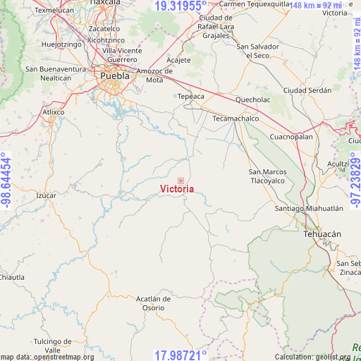
Victoria GPS coordinates[2]
18° 39' 16.884" North, 97° 56' 29.076" West
| Map corner | latitude | longitude |
|---|---|---|
| Upper-left | 19.31955°, | -98.64454° |
| Center: | 18.65469°, | -97.94141° |
| Lower-right: | 17.98721°, | -97.23829° |
| Map W x H: | 148.1×148.1 km | = 92×92mi |
| max Lat: | 32.7° ⇑70.7% North |
| Victoria: | 18.65469° |
| min Lat: | ⇓29.3% South 14.53588° |
| min Long | Victoria | max Long |
| -117.105° | -97.94141° | -86.73105° |
| W 64.3%⇐ | ⇒35.7% E |
Elevation
Elevation of Victoria is 1664 m = 5459 ft, and this is 410.3 m = 1346 ft above average elevation for this country.
| Max E: |
3497 m = 11473 ft | 42.8% |
| Victoria | 1664 m 5459 ft | |
| Avg. | 1253.7 m = 4113 ft | |
Min E: |
-1 m = -3 ft | 57.2% |
See also: Mexico elevation on elevation.city.
Geographical zone
Victoria is located in North Torrid zone (between Equator and Tropic of Cancer). Distance of this Northern Tropic circle is 531.7 km =330.4 mi to North.| Distance of | km | miles | from Victoria |
|---|---|---|---|
| North Pole | 7932.9 | 4929.3 | to North |
| Arctic Circle | 5327 | 3310 | to North |
| Tropic Cancer | 531.7 | 330.4 | to North |
| Equator | 2074.2 | 1288.8 | to South |


Nearby cities:
15 places around Victoria: (largest is in red/bold)
• Chigmecatitlán
13.8 km =8.6 mi,  266°
266°
• Colonia Morelos (Pie de Vaca)
7.1 km =4.4 mi,  157°
157°
• Dolores Hidalgo
14.2 km =8.8 mi,  36°
36°
• El Progreso
13.7 km =8.5 mi,  139°
139°
• El Rosario Xochitiopan
2.5 km =1.6 mi,  220°
220°
• Huatlatlauca
11.9 km =7.4 mi,  284°
284°
• Moralillo
11.9 km =7.4 mi,  181°
181°
• San Andrés Mimiahuapan
6.8 km =4.2 mi,  57°
57°
• San José de Gracia
10 km =6.2 mi,  97°
97°
• San Juan Atzompa
13.3 km =8.3 mi,  318°
318°
• San Luis Tehuizotla
9.1 km =5.7 mi,  74°
74°
• Santa Clara Huitziltepec
14.2 km =8.8 mi,  26°
26°
• Santa Cruz Huitziltepec
11.1 km =6.9 mi, 38°
• Tepexi de Rodríguez
8.3 km =5.2 mi,  168°
168°
• Tula
13.3 km =8.3 mi, 165°
Sources, notices
• [Note1] Compared only with cities in Mexico existing in our database
• [Src1] Map data: © OpenStreetMap contributors (CC-BY-SA)
• [Src2] Other city data from geonames.org with taken over terms of usage.
• [Src3] Geographical zone / Annual Mean Temperature by Robert A. Rohde @ Wikipedia
