Dolores Hidalgo geodata
Dolores Hidalgo (Puebla) is a populated place; located in Mexico in America/Mexico_City (GMT-6) time zone. With population of 1,082 people, there are 8049 cities with bigger population in this country. Compared to other cities in Mexico, 69.4% of cities are located further ↑North; 65.3% of cities are located further ←West and 70.3% of cities have lower elevation than Dolores Hidalgo. Note1


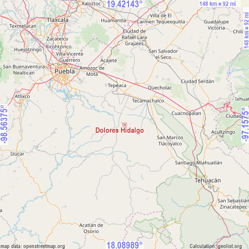
Dolores Hidalgo GPS coordinates[2]
18° 45' 25.092" North, 97° 51' 38.232" West
| Map corner | latitude | longitude |
|---|---|---|
| Upper-left | 19.42143°, | -98.56375° |
| Center: | 18.75697°, | -97.86062° |
| Lower-right: | 18.08989°, | -97.1575° |
| Map W x H: | 148.1×148.1 km | = 92×92mi |
| max Lat: | 32.7° ⇑69.4% North |
| Dolores Hidalgo: | 18.75697° |
| min Lat: | ⇓30.6% South 14.53588° |
| min Long | Dolores Hidalgo | max Long |
| -117.105° | -97.86062° | -86.73105° |
| W 65.3%⇐ | ⇒34.7% E |
Elevation
Elevation of Dolores Hidalgo is 1930 m = 6332 ft, and this is 676.3 m = 2219 ft above average elevation for this country.
| Max E: |
3497 m = 11473 ft | 29.7% |
| Dolores Hidalgo | 1930 m 6332 ft | |
| Avg. | 1253.7 m = 4113 ft | |
Min E: |
-1 m = -3 ft | 70.3% |
See also: Mexico elevation on elevation.city.
Geographical zone
Dolores Hidalgo is located in North Torrid zone (between Equator and Tropic of Cancer). Distance of this Northern Tropic circle is 520.3 km =323.3 mi to North.| Distance of | km | miles | from Dolores Hidalgo |
|---|---|---|---|
| North Pole | 7921.5 | 4922.2 | to North |
| Arctic Circle | 5315.6 | 3303 | to North |
| Tropic Cancer | 520.3 | 323.3 | to North |
| Equator | 2085.6 | 1295.9 | to South |


Nearby cities:
15 places around Dolores Hidalgo: (largest is in red/bold)
• Atoyatempan
8.9 km =5.5 mi,  320°
320°
• Huacaltzingo
4.7 km =2.9 mi,  359°
359°
• La Purísima
10.7 km =6.6 mi,  40°
40°
• La Soledad
11.7 km =7.3 mi,  59°
59°
• Ometepec
10.9 km =6.8 mi,  3°
3°
• San Andrés Mimiahuapan
8.2 km =5.1 mi,  199°
199°
• San Antonio la Portilla
11.2 km =7 mi,  67°
67°
• San Baltazar
11.5 km =7.1 mi, 74°
• San Luis Tehuizotla
9 km =5.6 mi,  178°
178°
• Santa Ana Coapan
8.9 km =5.5 mi,  338°
338°
• Santa Clara Huitziltepec
2.5 km =1.6 mi,  301°
301°
• Santa Cruz Huitziltepec
3.1 km =1.9 mi,  211°
211°
• Tepeyahualco
6.6 km =4.1 mi, 344°
• Tochtepec
10 km =6.2 mi,  23°
23°
• Xochitlan Todos Santos
10.7 km =6.6 mi,  123°
123°
Sources, notices
• [Note1] Compared only with cities in Mexico existing in our database
• [Src1] Map data: © OpenStreetMap contributors (CC-BY-SA)
• [Src2] Other city data from geonames.org with taken over terms of usage.
• [Src3] Geographical zone / Annual Mean Temperature by Robert A. Rohde @ Wikipedia
