El Progreso geodata
El Progreso (Puebla) is a populated place; located in Mexico in America/Mexico_City (GMT-6) time zone. With population of 1,053 people, there are 8288 cities with bigger population in this country. Compared to other cities in Mexico, 71.9% of cities are located further ↑North; 65.3% of cities are located further ←West and 68% of cities have lower elevation than El Progreso. Note1


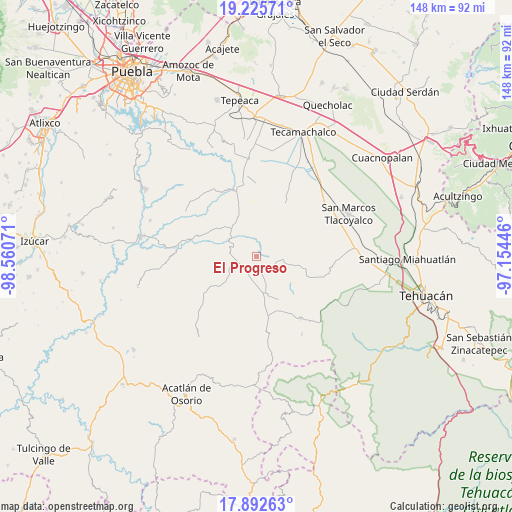
El Progreso GPS coordinates[2]
18° 33' 37.692" North, 97° 51' 27.288" West
| Map corner | latitude | longitude |
|---|---|---|
| Upper-left | 19.22571°, | -98.56071° |
| Center: | 18.56047°, | -97.85758° |
| Lower-right: | 17.89263°, | -97.15446° |
| Map W x H: | 148.2×148.2 km | = 92.1×92.1mi |
| max Lat: | 32.7° ⇑71.9% North |
| El Progreso: | 18.56047° |
| min Lat: | ⇓28.1% South 14.53588° |
| min Long | El Progreso | max Long |
| -117.105° | -97.85758° | -86.73105° |
| W 65.3%⇐ | ⇒34.7% E |
Elevation
Elevation of El Progreso is 1891 m = 6204 ft, and this is 637.3 m = 2091 ft above average elevation for this country.
| Max E: |
3497 m = 11473 ft | 32% |
| El Progreso | 1891 m 6204 ft | |
| Avg. | 1253.7 m = 4113 ft | |
Min E: |
-1 m = -3 ft | 68% |
See also: Mexico elevation on elevation.city.
Geographical zone
El Progreso is located in North Torrid zone (between Equator and Tropic of Cancer). Distance of this Northern Tropic circle is 542.2 km =336.9 mi to North.| Distance of | km | miles | from El Progreso |
|---|---|---|---|
| North Pole | 7943.3 | 4935.7 | to North |
| Arctic Circle | 5337.4 | 3316.5 | to North |
| Tropic Cancer | 542.2 | 336.9 | to North |
| Equator | 2063.7 | 1282.3 | to South |


Nearby cities:
15 places around El Progreso: (largest is in red/bold)
• Agua Santa Ana
11.4 km =7.1 mi,  244°
244°
• Colonia Morelos (Pie de Vaca)
7.3 km =4.5 mi,  302°
302°
• El Rosario Xochitiopan
13.5 km =8.4 mi,  309°
309°
• Guadalupe Victoria
3 km =1.9 mi,  153°
153°
• Huajoyuca
10 km =6.2 mi, 237°
• Huejonapan
12.1 km =7.5 mi,  213°
213°
• Juan N. Méndez
9.2 km =5.7 mi,  101°
101°
• Magdalena Alquizapán
13.5 km =8.4 mi,  130°
130°
• Mariscala
7.9 km =4.9 mi,  233°
233°
• Moralillo
9.2 km =5.7 mi,  261°
261°
• San José de Gracia
9.3 km =5.8 mi,  6°
6°
• San Juan Ixcaquixtla
11.4 km =7.1 mi,  165°
165°
• San Luis Tehuizotla
12.9 km =8 mi,  359°
359°
• Tepexi de Rodríguez
7.6 km =4.7 mi,  287°
287°
• Tula
6 km =3.7 mi,  245°
245°
Sources, notices
• [Note1] Compared only with cities in Mexico existing in our database
• [Src1] Map data: © OpenStreetMap contributors (CC-BY-SA)
• [Src2] Other city data from geonames.org with taken over terms of usage.
• [Src3] Geographical zone / Annual Mean Temperature by Robert A. Rohde @ Wikipedia
