Xoyatla geodata
Xoyatla (Puebla) is a populated place; located in Mexico in America/Mexico_City (GMT-6) time zone. With population of 839 people, there are 10431 cities with bigger population in this country. Compared to other cities in Mexico, 69.5% of cities are located further ↑North; 58.7% of cities are located further ←West and 50.8% of cities have lower elevation than Xoyatla. Note1


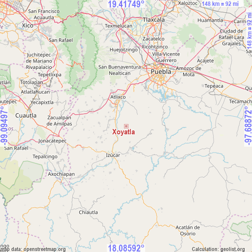
Xoyatla GPS coordinates[2]
18° 45' 10.872" North, 98° 23' 30.624" West
| Map corner | latitude | longitude |
|---|---|---|
| Upper-left | 19.41749°, | -99.09497° |
| Center: | 18.75302°, | -98.39184° |
| Lower-right: | 18.08592°, | -97.68872° |
| Map W x H: | 148.1×148.1 km | = 92×92mi |
| max Lat: | 32.7° ⇑69.5% North |
| Xoyatla: | 18.75302° |
| min Lat: | ⇓30.5% South 14.53588° |
| min Long | Xoyatla | max Long |
| -117.105° | -98.39184° | -86.73105° |
| W 58.7%⇐ | ⇒41.3% E |
Elevation
Elevation of Xoyatla is 1477 m = 4846 ft, and this is 223.3 m = 733 ft above average elevation for this country.
| Max E: |
3497 m = 11473 ft | 49.2% |
| Xoyatla | 1477 m 4846 ft | |
| Avg. | 1253.7 m = 4113 ft | |
Min E: |
-1 m = -3 ft | 50.8% |
See also: Mexico elevation on elevation.city.
Geographical zone
Xoyatla is located in North Torrid zone (between Equator and Tropic of Cancer). Distance of this Northern Tropic circle is 520.8 km =323.6 mi to North.| Distance of | km | miles | from Xoyatla |
|---|---|---|---|
| North Pole | 7921.9 | 4922.4 | to North |
| Arctic Circle | 5316 | 3303.2 | to North |
| Tropic Cancer | 520.8 | 323.6 | to North |
| Equator | 2085.1 | 1295.6 | to South |


Nearby cities:
15 places around Xoyatla: (largest is in red/bold)
• Ayotla
9.4 km =5.8 mi,  167°
167°
• Cacaloxúchitl
10.6 km =6.6 mi,  291°
291°
• La Galarza
11.6 km =7.2 mi,  215°
215°
• Mártir Cuauhtémoc (San José Cuauhtémoc)
8.9 km =5.5 mi,  305°
305°
• San Jerónimo Caleras
11.5 km =7.1 mi,  27°
27°
• San Juan Huiluco
7.3 km =4.5 mi,  303°
303°
• San Juan Vallarta
11.7 km =7.3 mi,  259°
259°
• San Pedro Teyuca
6.1 km =3.8 mi,  271°
271°
• Santa Ana Coatepec
10.3 km =6.4 mi,  334°
334°
• Santa María Xoyatla
0.3 km =0.2 mi,  40°
40°
• Soto y Gama
9.8 km =6.1 mi,  275°
275°
• Tepeojuma
6.5 km =4 mi,  241°
241°
• Tezonteopan de Bonilla
10.5 km =6.5 mi, 266°
• Totoltepec
12.1 km =7.5 mi,  157°
157°
• Tronconal
11.3 km =7 mi, 300°
Sources, notices
• [Note1] Compared only with cities in Mexico existing in our database
• [Src1] Map data: © OpenStreetMap contributors (CC-BY-SA)
• [Src2] Other city data from geonames.org with taken over terms of usage.
• [Src3] Geographical zone / Annual Mean Temperature by Robert A. Rohde @ Wikipedia
