La Galarza geodata
La Galarza (Puebla) is a populated place; located in Mexico in America/Mexico_City (GMT-6) time zone. With population of 4,063 people, there are 2243 cities with bigger population in this country. Compared to other cities in Mexico, 70.6% of cities are located further ↑North; 57.8% of cities are located further ←West and 50.7% of cities have higher elevation than La Galarza. Note1


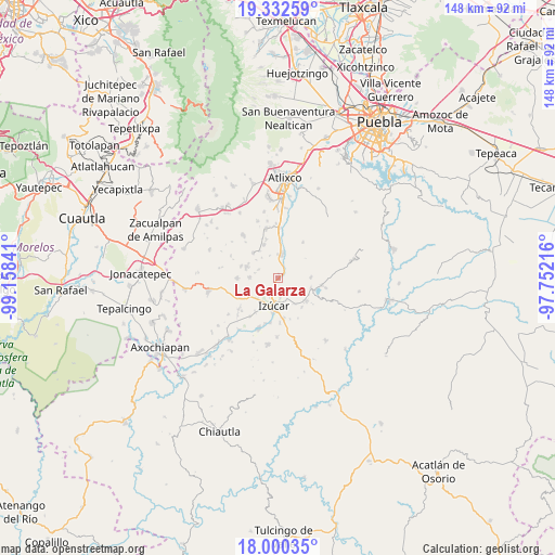
La Galarza GPS coordinates[2]
18° 40' 4.008" North, 98° 27' 19.008" West
| Map corner | latitude | longitude |
|---|---|---|
| Upper-left | 19.33259°, | -99.15841° |
| Center: | 18.66778°, | -98.45528° |
| Lower-right: | 18.00035°, | -97.75216° |
| Map W x H: | 148.1×148.1 km | = 92×92mi |
| max Lat: | 32.7° ⇑70.6% North |
| La Galarza: | 18.66778° |
| min Lat: | ⇓29.4% South 14.53588° |
| min Long | La Galarza | max Long |
| -117.105° | -98.45528° | -86.73105° |
| W 57.8%⇐ | ⇒42.2% E |
Elevation
Elevation of La Galarza is 1396 m = 4580 ft, and this is 142.3 m = 467 ft above average elevation for this country.
| Max E: |
3497 m = 11473 ft | 50.7% |
| La Galarza | 1396 m 4580 ft | |
| Avg. | 1253.7 m = 4113 ft | |
Min E: |
-1 m = -3 ft | 49.3% |
See also: Mexico elevation on elevation.city.
Geographical zone
La Galarza is located in North Torrid zone (between Equator and Tropic of Cancer). Distance of this Northern Tropic circle is 530.3 km =329.5 mi to North.| Distance of | km | miles | from La Galarza |
|---|---|---|---|
| North Pole | 7931.4 | 4928.3 | to North |
| Arctic Circle | 5325.5 | 3309.1 | to North |
| Tropic Cancer | 530.3 | 329.5 | to North |
| Equator | 2075.7 | 1289.8 | to South |


Nearby cities:
15 places around La Galarza: (largest is in red/bold)
• Agua Dulce
8 km =5 mi,  227°
227°
• Ayotla
8.7 km =5.4 mi,  88°
88°
• Colonia las Palmas
10.5 km =6.5 mi,  287°
287°
• Izúcar de Matamoros
7.4 km =4.6 mi,  185°
185°
• San Diego el Organal
9.5 km =5.9 mi,  317°
317°
• San José las Bocas
8 km =5 mi,  148°
148°
• San Juan Epatlán
9.2 km =5.7 mi,  107°
107°
• San Juan Vallarta
8.7 km =5.4 mi,  326°
326°
• San Pedro Calantla
10.1 km =6.3 mi,  141°
141°
• San Pedro Teyuca
9.7 km =6 mi,  3°
3°
• Santa Ana Necoxtla
9.7 km =6 mi,  128°
128°
• Tepapayeca
7.8 km =4.8 mi,  272°
272°
• Tepeojuma
6.4 km =4 mi,  8°
8°
• Tezonteopan de Bonilla
9.7 km =6 mi,  336°
336°
• Tlapanalá
9 km =5.6 mi, 290°
Sources, notices
• [Note1] Compared only with cities in Mexico existing in our database
• [Src1] Map data: © OpenStreetMap contributors (CC-BY-SA)
• [Src2] Other city data from geonames.org with taken over terms of usage.
• [Src3] Geographical zone / Annual Mean Temperature by Robert A. Rohde @ Wikipedia
