Tepeojuma geodata
Tepeojuma (Puebla) is a seat of a second-order administrative division; located in Mexico in America/Mexico_City (GMT-6) time zone. With population of 4,788 people, there are 1932 cities with bigger population in this country. Compared to other cities in Mexico, 70% of cities are located further ↑North; 58% of cities are located further ←West and 51.2% of cities have lower elevation than Tepeojuma. Note1


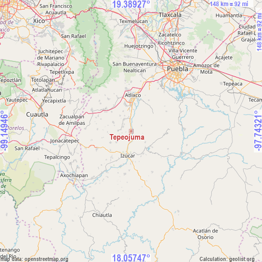
Tepeojuma GPS coordinates[2]
18° 43' 28.848" North, 98° 26' 46.788" West
| Map corner | latitude | longitude |
|---|---|---|
| Upper-left | 19.38927°, | -99.14946° |
| Center: | 18.72468°, | -98.44633° |
| Lower-right: | 18.05747°, | -97.74321° |
| Map W x H: | 148.1×148.1 km | = 92×92mi |
| max Lat: | 32.7° ⇑70% North |
| Tepeojuma: | 18.72468° |
| min Lat: | ⇓30% South 14.53588° |
| min Long | Tepeojuma | max Long |
| -117.105° | -98.44633° | -86.73105° |
| W 58%⇐ | ⇒42% E |
Elevation
Elevation of Tepeojuma is 1494 m = 4902 ft, and this is 240.3 m = 788 ft above average elevation for this country.
| Max E: |
3497 m = 11473 ft | 48.8% |
| Tepeojuma | 1494 m 4902 ft | |
| Avg. | 1253.7 m = 4113 ft | |
Min E: |
-1 m = -3 ft | 51.2% |
See also: Mexico elevation on elevation.city.
Geographical zone
Tepeojuma is located in North Torrid zone (between Equator and Tropic of Cancer). Distance of this Northern Tropic circle is 523.9 km =325.5 mi to North.| Distance of | km | miles | from Tepeojuma |
|---|---|---|---|
| North Pole | 7925.1 | 4924.4 | to North |
| Arctic Circle | 5319.2 | 3305.2 | to North |
| Tropic Cancer | 523.9 | 325.5 | to North |
| Equator | 2082 | 1293.7 | to South |


Nearby cities:
15 places around Tepeojuma: (largest is in red/bold)
• Ayotla
9.9 km =6.2 mi,  128°
128°
• Cacaloxúchitl
8.1 km =5 mi,  329°
329°
• La Galarza
6.4 km =4 mi,  188°
188°
• Mártir Cuauhtémoc (San José Cuauhtémoc)
8.5 km =5.3 mi,  349°
349°
• San Diego el Organal
7.4 km =4.6 mi,  275°
275°
• San Juan Huiluco
7.2 km =4.5 mi,  357°
357°
• San Juan Vallarta
5.8 km =3.6 mi, 279°
• San Pedro Teyuca
3.4 km =2.1 mi, 353°
• Santa María Xoyatla
6.8 km =4.2 mi,  60°
60°
• Santiago Tetla
10 km =6.2 mi,  288°
288°
• Soto y Gama
5.8 km =3.6 mi,  315°
315°
• Tezonteopan de Bonilla
5.4 km =3.4 mi,  298°
298°
• Tlapanalá
9.9 km =6.2 mi,  251°
251°
• Tronconal
9.8 km =6.1 mi,  336°
336°
• Xoyatla
6.5 km =4 mi, 61°
Sources, notices
• [Note1] Compared only with cities in Mexico existing in our database
• [Src1] Map data: © OpenStreetMap contributors (CC-BY-SA)
• [Src2] Other city data from geonames.org with taken over terms of usage.
• [Src3] Geographical zone / Annual Mean Temperature by Robert A. Rohde @ Wikipedia
