Tronconal geodata
Tronconal (Puebla) is a populated place; located in Mexico in America/Mexico_City (GMT-6) time zone. With population of 1,424 people, there are 6068 cities with bigger population in this country. Compared to other cities in Mexico, 68.7% of cities are located further ↑North; 57.5% of cities are located further ←West and 57.7% of cities have lower elevation than Tronconal. Note1


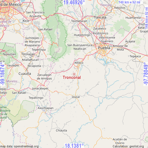
Tronconal GPS coordinates[2]
18° 48' 18" North, 98° 29' 0.996" West
| Map corner | latitude | longitude |
|---|---|---|
| Upper-left | 19.46926°, | -99.18674° |
| Center: | 18.805°, | -98.48361° |
| Lower-right: | 18.1381°, | -97.78049° |
| Map W x H: | 148×148 km | = 92×92mi |
| max Lat: | 32.7° ⇑68.7% North |
| Tronconal: | 18.805° |
| min Lat: | ⇓31.3% South 14.53588° |
| min Long | Tronconal | max Long |
| -117.105° | -98.48361° | -86.73105° |
| W 57.5%⇐ | ⇒42.5% E |
Elevation
Elevation of Tronconal is 1682 m = 5518 ft, and this is 428.3 m = 1405 ft above average elevation for this country.
| Max E: |
3497 m = 11473 ft | 42.3% |
| Tronconal | 1682 m 5518 ft | |
| Avg. | 1253.7 m = 4113 ft | |
Min E: |
-1 m = -3 ft | 57.7% |
See also: Mexico elevation on elevation.city.
Geographical zone
Tronconal is located in North Torrid zone (between Equator and Tropic of Cancer). Distance of this Northern Tropic circle is 515 km =320 mi to North.| Distance of | km | miles | from Tronconal |
|---|---|---|---|
| North Pole | 7916.1 | 4918.8 | to North |
| Arctic Circle | 5310.3 | 3299.7 | to North |
| Tropic Cancer | 515 | 320 | to North |
| Equator | 2090.9 | 1299.2 | to South |


Nearby cities:
15 places around Tronconal: (largest is in red/bold)
• Cacaloxúchitl
2 km =1.2 mi,  187°
187°
• Huaquechula
7.4 km =4.6 mi,  239°
239°
• Mártir Cuauhtémoc (San José Cuauhtémoc)
2.5 km =1.6 mi,  103°
103°
• San Diego el Organal
9 km =5.6 mi,  202°
202°
• San Juan Huiluco
4 km =2.5 mi,  116°
116°
• San Juan Tejupa
8.2 km =5.1 mi,  312°
312°
• San Juan Vallarta
8.2 km =5.1 mi, 192°
• San Miguel Aguacomulican
7.3 km =4.5 mi,  285°
285°
• San Pedro Teyuca
6.6 km =4.1 mi,  147°
147°
• Santa Ana Coatepec
6.2 km =3.9 mi,  55°
55°
• Santiago Tetla
8 km =5 mi,  224°
224°
• Soledad Morelos
2.6 km =1.6 mi,  346°
346°
• Soto y Gama
4.8 km =3 mi,  181°
181°
• Teacalco de Dorantes (San José Teacalco)
2.5 km =1.6 mi,  268°
268°
• Tezonteopan de Bonilla
6.4 km =4 mi, 187°
Sources, notices
• [Note1] Compared only with cities in Mexico existing in our database
• [Src1] Map data: © OpenStreetMap contributors (CC-BY-SA)
• [Src2] Other city data from geonames.org with taken over terms of usage.
• [Src3] Geographical zone / Annual Mean Temperature by Robert A. Rohde @ Wikipedia
