San Antonio Chiltepec geodata
San Antonio Chiltepec (Puebla) is a populated place; located in Mexico in America/Mexico_City (GMT-6) time zone. With population of 788 people, there are 11082 cities with bigger population in this country. Compared to other cities in Mexico, 78.6% of cities are located further ↑North; 61.5% of cities are located further ←West and 59% of cities have higher elevation than San Antonio Chiltepec. Note1
Current local time in San Antonio Chiltepec:
08:30 AM, WednesdayDifference from your time zone: hours


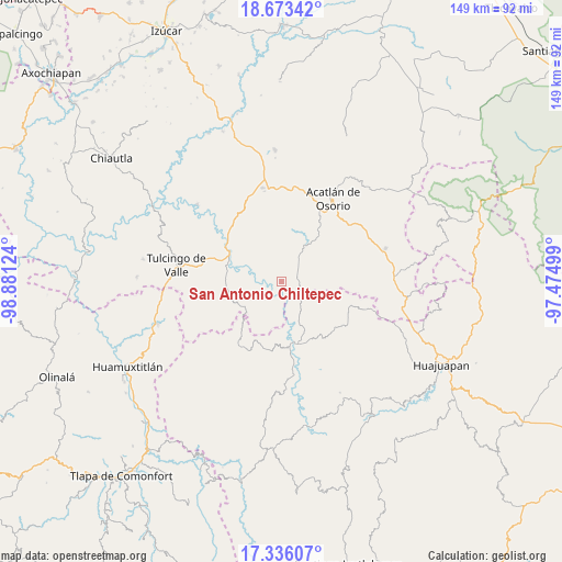
San Antonio Chiltepec GPS coordinates[2]
18° 0' 21.636" North, 98° 10' 41.196" West
| Map corner | latitude | longitude |
|---|---|---|
| Upper-left | 18.67342°, | -98.88124° |
| Center: | 18.00601°, | -98.17811° |
| Lower-right: | 17.33607°, | -97.47499° |
| Map W x H: | 148.7×148.7 km | = 92.4×92.4mi |
| max Lat: | 32.7° ⇑78.6% North |
| San Antonio Chiltepec: | 18.00601° |
| min Lat: | ⇓21.4% South 14.53588° |
| min Long | San Antonio Chi | max Long |
| -117.105° | -98.17811° | -86.73105° |
| W 61.5%⇐ | ⇒38.5% E |
Elevation
Elevation of San Antonio Chiltepec is 1053 m = 3455 ft, and this is 200.7 m = 658 ft below average elevation for this country.
| Max E: |
3497 m = 11473 ft | 59% |
| Avg. | 1253.7 m = 4113 ft | |
| San Antonio Chiltepec | 1053 m = 3455 ft | |
Min E: |
-1 m = -3 ft | 41% |
See also: Mexico elevation on elevation.city.
Geographical zone
San Antonio Chiltepec is located in North Torrid zone (between Equator and Tropic of Cancer). Distance of this Northern Tropic circle is 603.8 km =375.2 mi to North.| Distance of | km | miles | from San Antonio Chiltepec |
|---|---|---|---|
| North Pole | 8005 | 4974.1 | to North |
| Arctic Circle | 5399.1 | 3354.8 | to North |
| Tropic Cancer | 603.8 | 375.2 | to North |
| Equator | 2002.1 | 1244 | to South |


Nearby cities:
15 places around San Antonio Chiltepec: (largest is in red/bold)
• Guadalupe Santa Ana
11.3 km =7 mi,  32°
32°
• Ilamacingo
6.6 km =4.1 mi,  270°
270°
• Mariscala de Juárez
16.7 km =10.4 mi,  166°
166°
• Mixquitepec
9 km =5.6 mi,  24°
24°
• Mixquitlixco
17.8 km =11.1 mi, 34°
• Olomatlán
11.7 km =7.3 mi,  235°
235°
• Progreso
14.5 km =9 mi,  283°
283°
• San Isidro Labrador
15.9 km =9.9 mi,  45°
45°
• San Juan Llano Grande
11.8 km =7.3 mi,  55°
55°
• San Lorenzo Vista Hermosa
12.7 km =7.9 mi,  114°
114°
• San Pablo Anicano
16.4 km =10.2 mi,  36°
36°
• San Pedro Yeloixtlahuacan
16.3 km =10.1 mi, 40°
• Santa Catarina Estancia
18.4 km =11.4 mi, 107°
• Tecomatlán
18.4 km =11.4 mi,  308°
308°
• Vista Hermosa
9.1 km =5.7 mi, 31°
Sources, notices
• [Note1] Compared only with cities in Mexico existing in our database
• [Src1] Map data: © OpenStreetMap contributors (CC-BY-SA)
• [Src2] Other city data from geonames.org with taken over terms of usage.
• [Src3] Geographical zone / Annual Mean Temperature by Robert A. Rohde @ Wikipedia
