Olomatlán geodata
Olomatlán (Puebla) is a populated place; located in Mexico in America/Mexico_City (GMT-6) time zone. With population of 995 people, there are 8755 cities with bigger population in this country. Compared to other cities in Mexico, 79.2% of cities are located further ↑North; 60.3% of cities are located further ←West and 57.8% of cities have higher elevation than Olomatlán. Note1


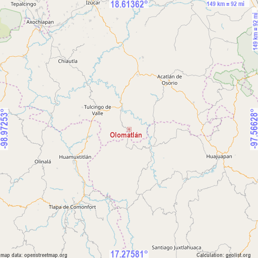
Olomatlán GPS coordinates[2]
17° 56' 45.528" North, 98° 16' 9.84" West
| Map corner | latitude | longitude |
|---|---|---|
| Upper-left | 18.61362°, | -98.97253° |
| Center: | 17.94598°, | -98.2694° |
| Lower-right: | 17.27581°, | -97.56628° |
| Map W x H: | 148.8×148.8 km | = 92.5×92.5mi |
| max Lat: | 32.7° ⇑79.2% North |
| Olomatlán: | 17.94598° |
| min Lat: | ⇓20.8% South 14.53588° |
| min Long | Olomatlán | max Long |
| -117.105° | -98.2694° | -86.73105° |
| W 60.3%⇐ | ⇒39.7% E |
Elevation
Elevation of Olomatlán is 1107 m = 3632 ft, and this is 146.7 m = 481 ft below average elevation for this country.
| Max E: |
3497 m = 11473 ft | 57.8% |
| Avg. | 1253.7 m = 4113 ft | |
| Olomatlán | 1107 m = 3632 ft | |
Min E: |
-1 m = -3 ft | 42.2% |
See also: Mexico elevation on elevation.city.
Geographical zone
Olomatlán is located in North Torrid zone (between Equator and Tropic of Cancer). Distance of this Northern Tropic circle is 610.5 km =379.3 mi to North.| Distance of | km | miles | from Olomatlán |
|---|---|---|---|
| North Pole | 8011.7 | 4978.2 | to North |
| Arctic Circle | 5405.8 | 3359 | to North |
| Tropic Cancer | 610.5 | 379.3 | to North |
| Equator | 1995.4 | 1239.9 | to South |


Nearby cities:
15 places around Olomatlán: (largest is in red/bold)
• Guadalupe Victoria
12.8 km =8 mi,  285°
285°
• Guadalupe del Recreo
17.6 km =10.9 mi,  202°
202°
• Ilamacingo
7.4 km =4.6 mi,  24°
24°
• Mariscala de Juárez
16.6 km =10.3 mi,  125°
125°
• Mixquitepec
20 km =12.4 mi,  42°
42°
• Progreso
11.1 km =6.9 mi,  336°
336°
• San Antonio Chiltepec
11.7 km =7.3 mi,  55°
55°
• San Juan la Ciénega
10.6 km =6.6 mi,  186°
186°
• San Miguel Tlaltepexi
16.6 km =10.3 mi,  258°
258°
• Santa Ana Rayón
9.6 km =6 mi, 191°
• Santa Cruz Tacache de Mina
17.9 km =11.1 mi,  136°
136°
• Tecomatlán
18.8 km =11.7 mi,  345°
345°
• Tulcingo de Valle
21.1 km =13.1 mi,  300°
300°
• Vista Hermosa
20.4 km =12.7 mi, 44°
• Xixingo de los Reyes
15.5 km =9.6 mi,  248°
248°
Sources, notices
• [Note1] Compared only with cities in Mexico existing in our database
• [Src1] Map data: © OpenStreetMap contributors (CC-BY-SA)
• [Src2] Other city data from geonames.org with taken over terms of usage.
• [Src3] Geographical zone / Annual Mean Temperature by Robert A. Rohde @ Wikipedia
