Mixquitlixco geodata
Mixquitlixco (Puebla) is a populated place; located in Mexico in America/Mexico_City (GMT-6) time zone. With population of 610 people, there are 14138 cities with bigger population in this country. Compared to other cities in Mexico, 77.1% of cities are located further ↑North; 62.6% of cities are located further ←West and 56.6% of cities have higher elevation than Mixquitlixco. Note1


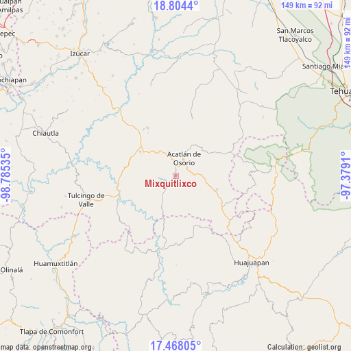
Mixquitlixco GPS coordinates[2]
18° 8' 15" North, 98° 4' 55.992" West
| Map corner | latitude | longitude |
|---|---|---|
| Upper-left | 18.8044°, | -98.78535° |
| Center: | 18.1375°, | -98.08222° |
| Lower-right: | 17.46805°, | -97.3791° |
| Map W x H: | 148.6×148.6 km | = 92.3×92.3mi |
| max Lat: | 32.7° ⇑77.1% North |
| Mixquitlixco: | 18.1375° |
| min Lat: | ⇓22.9% South 14.53588° |
| min Long | Mixquitlixco | max Long |
| -117.105° | -98.08222° | -86.73105° |
| W 62.6%⇐ | ⇒37.4% E |
Elevation
Elevation of Mixquitlixco is 1135 m = 3724 ft, and this is 118.7 m = 389 ft below average elevation for this country.
| Max E: |
3497 m = 11473 ft | 56.6% |
| Avg. | 1253.7 m = 4113 ft | |
| Mixquitlixco | 1135 m = 3724 ft | |
Min E: |
-1 m = -3 ft | 43.4% |
See also: Mexico elevation on elevation.city.
Geographical zone
Mixquitlixco is located in North Torrid zone (between Equator and Tropic of Cancer). Distance of this Northern Tropic circle is 589.2 km =366.1 mi to North.| Distance of | km | miles | from Mixquitlixco |
|---|---|---|---|
| North Pole | 7990.4 | 4965 | to North |
| Arctic Circle | 5384.5 | 3345.8 | to North |
| Tropic Cancer | 589.2 | 366.1 | to North |
| Equator | 2016.7 | 1253.1 | to South |


Nearby cities:
15 places around Mixquitlixco: (largest is in red/bold)
• Acatlán de Osorio
8.1 km =5 mi,  26°
26°
• Amatitlán de Azueta
4.4 km =2.7 mi,  8°
8°
• Guadalupe Santa Ana
6.5 km =4 mi,  218°
218°
• Hermenegildo Galeana
13.4 km =8.3 mi,  350°
350°
• Las Nieves
6.4 km =4 mi,  36°
36°
• Mixquitepec
9 km =5.6 mi, 224°
• San Bernardo
8.7 km =5.4 mi,  343°
343°
• San Francisco Rancho Nuevo
13.8 km =8.6 mi, 9°
• San Isidro Labrador
3.7 km =2.3 mi,  161°
161°
• San Juan Llano Grande
7.9 km =4.9 mi,  183°
183°
• San Pablo Anicano
1.5 km =0.9 mi,  191°
191°
• San Pedro Yeloixtlahuacan
2.3 km =1.4 mi,  166°
166°
• Tetelcingo
12.7 km =7.9 mi, 27°
• Texcalapa de Juárez
12.8 km =8 mi,  129°
129°
• Vista Hermosa
8.8 km =5.5 mi, 218°
Sources, notices
• [Note1] Compared only with cities in Mexico existing in our database
• [Src1] Map data: © OpenStreetMap contributors (CC-BY-SA)
• [Src2] Other city data from geonames.org with taken over terms of usage.
• [Src3] Geographical zone / Annual Mean Temperature by Robert A. Rohde @ Wikipedia
