Acatepec geodata
Acatepec (Puebla) is a populated place; located in Mexico in America/Mexico_City (GMT-6) time zone. With population of 3,066 people, there are 2939 cities with bigger population in this country. Compared to other cities in Mexico, 74.1% of cities are located further ↑North; 74.4% of cities are located further ←West and 93.3% of cities have lower elevation than Acatepec. Note1


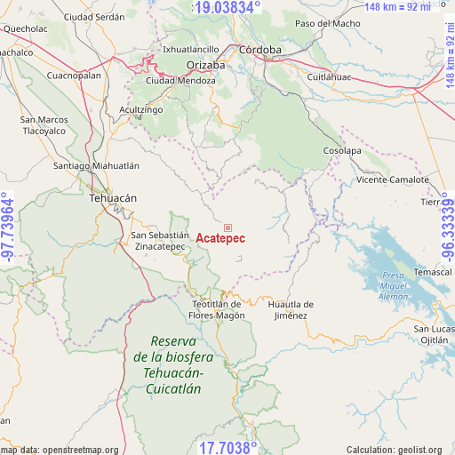
Acatepec GPS coordinates[2]
18° 22' 20.496" North, 97° 2' 11.436" West
| Map corner | latitude | longitude |
|---|---|---|
| Upper-left | 19.03834°, | -97.73964° |
| Center: | 18.37236°, | -97.03651° |
| Lower-right: | 17.7038°, | -96.33339° |
| Map W x H: | 148.4×148.4 km | = 92.2×92.2mi |
| max Lat: | 32.7° ⇑74.1% North |
| Acatepec: | 18.37236° |
| min Lat: | ⇓25.9% South 14.53588° |
| min Long | Acatepec | max Long |
| -117.105° | -97.03651° | -86.73105° |
| W 74.4%⇐ | ⇒25.6% E |
Elevation
Elevation of Acatepec is 2544 m = 8346 ft, and this is 1290.3 m = 4233 ft above average elevation for this country.
| Max E: |
3497 m = 11473 ft | 6.7% |
| Acatepec | 2544 m 8346 ft | |
| Avg. | 1253.7 m = 4113 ft | |
Min E: |
-1 m = -3 ft | 93.3% |
See also: Mexico elevation on elevation.city.
Geographical zone
Acatepec is located in North Torrid zone (between Equator and Tropic of Cancer). Distance of this Northern Tropic circle is 563.1 km =349.9 mi to North.| Distance of | km | miles | from Acatepec |
|---|---|---|---|
| North Pole | 7964.2 | 4948.7 | to North |
| Arctic Circle | 5358.4 | 3329.6 | to North |
| Tropic Cancer | 563.1 | 349.9 | to North |
| Equator | 2042.8 | 1269.3 | to South |


Nearby cities:
15 places around Acatepec: (largest is in red/bold)
• Boca del Monte
4.9 km =3 mi,  293°
293°
• Cacaloc
7 km =4.3 mi,  252°
252°
• Chichicapa
3.3 km =2.1 mi,  340°
340°
• Cinco Señores
4.4 km =2.7 mi,  267°
267°
• Cuabcapula
4.9 km =3 mi,  20°
20°
• Loma Bonita
4.1 km =2.5 mi,  5°
5°
• Mexcaltochintla
5.5 km =3.4 mi,  350°
350°
• San Sebastián Alcomunga
7.3 km =4.5 mi, 8°
• Tecoltepec
6.9 km =4.3 mi,  220°
220°
• Tepetlampa
6.1 km =3.8 mi, 338°
• Xitlama
7.9 km =4.9 mi,  165°
165°
• Zacatlamanic
6.9 km =4.3 mi, 354°
• Zoquitlanzacualco
4.9 km =3 mi,  176°
176°
• Zoquitlán
4.6 km =2.9 mi,  154°
154°
• Ízhuapa
2.3 km =1.4 mi,  56°
56°
Sources, notices
• [Note1] Compared only with cities in Mexico existing in our database
• [Src1] Map data: © OpenStreetMap contributors (CC-BY-SA)
• [Src2] Other city data from geonames.org with taken over terms of usage.
• [Src3] Geographical zone / Annual Mean Temperature by Robert A. Rohde @ Wikipedia
