Tecoltepec geodata
Tecoltepec (Puebla) is a populated place; located in Mexico in America/Mexico_City (GMT-6) time zone. With population of 1,292 people, there are 6710 cities with bigger population in this country. Compared to other cities in Mexico, 74.6% of cities are located further ↑North; 73.9% of cities are located further ←West and 84.1% of cities have lower elevation than Tecoltepec. Note1


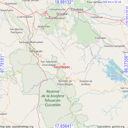
Tecoltepec GPS coordinates[2]
18° 19' 30.54" North, 97° 4' 43.248" West
| Map corner | latitude | longitude |
|---|---|---|
| Upper-left | 18.99132°, | -97.78181° |
| Center: | 18.32515°, | -97.07868° |
| Lower-right: | 17.65641°, | -96.37556° |
| Map W x H: | 148.4×148.4 km | = 92.2×92.2mi |
| max Lat: | 32.7° ⇑74.6% North |
| Tecoltepec: | 18.32515° |
| min Lat: | ⇓25.4% South 14.53588° |
| min Long | Tecoltepec | max Long |
| -117.105° | -97.07868° | -86.73105° |
| W 73.9%⇐ | ⇒26.1% E |
Elevation
Elevation of Tecoltepec is 2244 m = 7362 ft, and this is 990.3 m = 3249 ft above average elevation for this country.
| Max E: |
3497 m = 11473 ft | 15.9% |
| Tecoltepec | 2244 m 7362 ft | |
| Avg. | 1253.7 m = 4113 ft | |
Min E: |
-1 m = -3 ft | 84.1% |
See also: Mexico elevation on elevation.city.
Geographical zone
Tecoltepec is located in North Torrid zone (between Equator and Tropic of Cancer). Distance of this Northern Tropic circle is 568.4 km =353.2 mi to North.| Distance of | km | miles | from Tecoltepec |
|---|---|---|---|
| North Pole | 7969.5 | 4952 | to North |
| Arctic Circle | 5363.6 | 3332.8 | to North |
| Tropic Cancer | 568.4 | 353.2 | to North |
| Equator | 2037.6 | 1266.1 | to South |


Nearby cities:
15 places around Tecoltepec: (largest is in red/bold)
• Acatepec
6.9 km =4.3 mi,  40°
40°
• Boca del Monte
7.2 km =4.5 mi,  359°
359°
• Cacaloc
3.8 km =2.4 mi,  324°
324°
• Calipan
9.6 km =6 mi,  249°
249°
• Chichicapa
9 km =5.6 mi,  21°
21°
• Chichiltepec
9.6 km =6 mi,  187°
187°
• Cinco Señores
5.1 km =3.2 mi,  0°
0°
• Coxcatlán
10 km =6.2 mi,  229°
229°
• Ocotlamanic
1.9 km =1.2 mi,  265°
265°
• Segunda Sección
8.9 km =5.5 mi,  120°
120°
• Tlixco
10.1 km =6.3 mi, 124°
• Xitlama
6.9 km =4.3 mi,  110°
110°
• Zoquitlanzacualco
4.8 km =3 mi,  86°
86°
• Zoquitlán
6.6 km =4.1 mi,  80°
80°
• Ízhuapa
9.1 km =5.7 mi, 44°
Sources, notices
• [Note1] Compared only with cities in Mexico existing in our database
• [Src1] Map data: © OpenStreetMap contributors (CC-BY-SA)
• [Src2] Other city data from geonames.org with taken over terms of usage.
• [Src3] Geographical zone / Annual Mean Temperature by Robert A. Rohde @ Wikipedia
