Ignacio Gutiérrez geodata
Ignacio Gutiérrez (Campeche) is a populated place; located in Mexico in America/Merida (GMT-6) time zone. With population of 634 people, there are 13664 cities with bigger population in this country. Compared to other cities in Mexico, 67% of cities are located further ↑North; 96.8% of cities are located further ←West and 95.7% of cities have higher elevation than Ignacio Gutiérrez. Note1


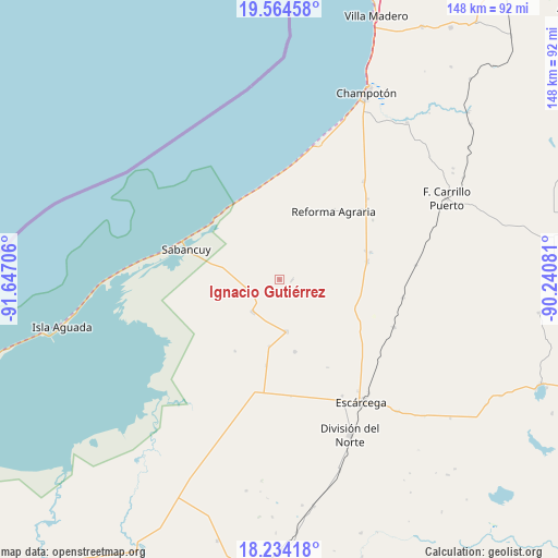
Ignacio Gutiérrez GPS coordinates[2]
18° 54' 2.52" North, 90° 56' 38.148" West
| Map corner | latitude | longitude |
|---|---|---|
| Upper-left | 19.56458°, | -91.64706° |
| Center: | 18.9007°, | -90.94393° |
| Lower-right: | 18.23418°, | -90.24081° |
| Map W x H: | 147.9×147.9 km | = 91.9×91.9mi |
| max Lat: | 32.7° ⇑67% North |
| Ignacio Gutiérrez: | 18.9007° |
| min Lat: | ⇓33% South 14.53588° |
| min Long | Ignacio Gutiér | max Long |
| -117.105° | -90.94393° | -86.73105° |
| W 96.8%⇐ | ⇒3.2% E |
Elevation
Elevation of Ignacio Gutiérrez is 12 m = 39 ft, and this is 1241.7 m = 4074 ft below average elevation for this country.
| Max E: |
3497 m = 11473 ft | 95.7% |
| Avg. | 1253.7 m = 4113 ft | |
| Ignacio Gutiérrez | 12 m = 39 ft | |
Min E: |
-1 m = -3 ft | 4.3% |
See also: Mexico elevation on elevation.city.
Geographical zone
Ignacio Gutiérrez is located in North Torrid zone (between Equator and Tropic of Cancer). Distance of this Northern Tropic circle is 504.4 km =313.4 mi to North.| Distance of | km | miles | from Ignacio Gutiérrez |
|---|---|---|---|
| North Pole | 7905.5 | 4912.2 | to North |
| Arctic Circle | 5299.6 | 3293 | to North |
| Tropic Cancer | 504.4 | 313.4 | to North |
| Equator | 2101.6 | 1305.9 | to South |


Nearby cities:
15 places around Ignacio Gutiérrez: (largest is in red/bold)
• Abelardo L. Rodríguez
19.6 km =12.2 mi,  167°
167°
• Aquiles Serdán (Chuiná)
25.2 km =15.7 mi,  73°
73°
• Chicbul
14.1 km =8.8 mi, 171°
• Cinco de Febrero
33 km =20.5 mi,  98°
98°
• General Ortiz Ávila
24.1 km =15 mi, 71°
• José María Morelos y Pavón
31.6 km =19.6 mi,  47°
47°
• La Cristalina
22.4 km =13.9 mi,  211°
211°
• Licenciado Gustavo Díaz Ordaz (18 de Marzo)
30.5 km =19 mi,  191°
191°
• Nuevo Progreso Dos
31.2 km =19.4 mi, 174°
• Oxcabal
4.7 km =2.9 mi, 210°
• Plan de Ayala
13.8 km =8.6 mi, 173°
• Revolución
22.5 km =14 mi,  89°
89°
• Sabancuy
25.9 km =16.1 mi,  288°
288°
• San Isidro
31.7 km =19.7 mi,  200°
200°
• Xbacab
23.8 km =14.8 mi,  79°
79°
Sources, notices
• [Note1] Compared only with cities in Mexico existing in our database
• [Src1] Map data: © OpenStreetMap contributors (CC-BY-SA)
• [Src2] Other city data from geonames.org with taken over terms of usage.
• [Src3] Geographical zone / Annual Mean Temperature by Robert A. Rohde @ Wikipedia
