Plan de Ayala geodata
Plan de Ayala (Campeche) is a populated place; located in Mexico in America/Merida (GMT-6) time zone. With population of 771 people, there are 11338 cities with bigger population in this country. Compared to other cities in Mexico, 69.1% of cities are located further ↑North; 96.9% of cities are located further ←West and 90% of cities have higher elevation than Plan de Ayala. Note1


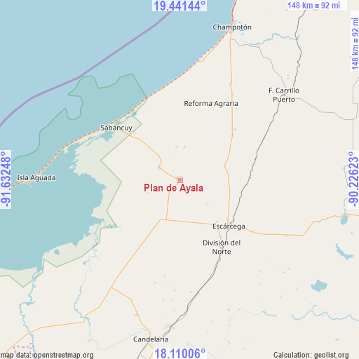
Plan de Ayala GPS coordinates[2]
18° 46' 37.416" North, 90° 55' 45.66" West
| Map corner | latitude | longitude |
|---|---|---|
| Upper-left | 19.44144°, | -91.63248° |
| Center: | 18.77706°, | -90.92935° |
| Lower-right: | 18.11006°, | -90.22623° |
| Map W x H: | 148×148 km | = 92×92mi |
| max Lat: | 32.7° ⇑69.1% North |
| Plan de Ayala: | 18.77706° |
| min Lat: | ⇓30.9% South 14.53588° |
| min Long | Plan de Ayala | max Long |
| -117.105° | -90.92935° | -86.73105° |
| W 96.9%⇐ | ⇒3.1% E |
Elevation
Elevation of Plan de Ayala is 24 m = 79 ft, and this is 1229.7 m = 4034 ft below average elevation for this country.
| Max E: |
3497 m = 11473 ft | 90% |
| Avg. | 1253.7 m = 4113 ft | |
| Plan de Ayala | 24 m = 79 ft | |
Min E: |
-1 m = -3 ft | 10% |
See also: Mexico elevation on elevation.city.
Geographical zone
Plan de Ayala is located in North Torrid zone (between Equator and Tropic of Cancer). Distance of this Northern Tropic circle is 518.1 km =321.9 mi to North.| Distance of | km | miles | from Plan de Ayala |
|---|---|---|---|
| North Pole | 7919.2 | 4920.8 | to North |
| Arctic Circle | 5313.4 | 3301.6 | to North |
| Tropic Cancer | 518.1 | 321.9 | to North |
| Equator | 2087.8 | 1297.3 | to South |


Nearby cities:
15 places around Plan de Ayala: (largest is in red/bold)
• Abelardo L. Rodríguez
6 km =3.7 mi,  154°
154°
• Chicbul
0.6 km =0.4 mi,  107°
107°
• Escárcega
26.9 km =16.7 mi,  133°
133°
• General Ortiz Ávila
30.1 km =18.7 mi,  45°
45°
• Ignacio Gutiérrez
13.8 km =8.6 mi,  353°
353°
• José de la Cruz Blanco
23 km =14.3 mi,  138°
138°
• La Cristalina
14.3 km =8.9 mi,  248°
248°
• Licenciado Gustavo Díaz Ordaz (18 de Marzo)
17.9 km =11.1 mi,  205°
205°
• Miguel Colorado
28.9 km =18 mi,  88°
88°
• Nuevo Progreso Dos
17.4 km =10.8 mi,  175°
175°
• Oxcabal
10.5 km =6.5 mi,  337°
337°
• Pital Nuevo
22.6 km =14 mi, 208°
• Revolución
25.2 km =15.7 mi,  56°
56°
• San Isidro
20.4 km =12.7 mi,  218°
218°
• Xbacab
28.5 km =17.7 mi, 50°
Sources, notices
• [Note1] Compared only with cities in Mexico existing in our database
• [Src1] Map data: © OpenStreetMap contributors (CC-BY-SA)
• [Src2] Other city data from geonames.org with taken over terms of usage.
• [Src3] Geographical zone / Annual Mean Temperature by Robert A. Rohde @ Wikipedia
