Xbacab geodata
Xbacab (Campeche) is a populated place; located in Mexico in America/Merida (GMT-6) time zone. With population of 1,649 people, there are 5260 cities with bigger population in this country. Compared to other cities in Mexico, 66% of cities are located further ↑North; 97% of cities are located further ←West and 91.2% of cities have higher elevation than Xbacab. Note1


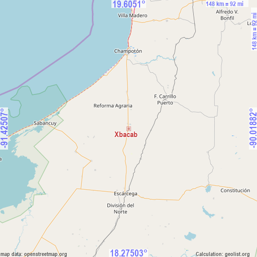
Xbacab GPS coordinates[2]
18° 56' 29.004" North, 90° 43' 18.984" West
| Map corner | latitude | longitude |
|---|---|---|
| Upper-left | 19.6051°, | -91.42507° |
| Center: | 18.94139°, | -90.72194° |
| Lower-right: | 18.27503°, | -90.01882° |
| Map W x H: | 147.9×147.9 km | = 91.9×91.9mi |
| max Lat: | 32.7° ⇑66% North |
| Xbacab: | 18.94139° |
| min Lat: | ⇓34% South 14.53588° |
| min Long | Xbacab | max Long |
| -117.105° | -90.72194° | -86.73105° |
| W 97%⇐ | ⇒3% E |
Elevation
Elevation of Xbacab is 21 m = 69 ft, and this is 1232.7 m = 4044 ft below average elevation for this country.
| Max E: |
3497 m = 11473 ft | 91.2% |
| Avg. | 1253.7 m = 4113 ft | |
| Xbacab | 21 m = 69 ft | |
Min E: |
-1 m = -3 ft | 8.8% |
See also: Mexico elevation on elevation.city.
Geographical zone
Xbacab is located in North Torrid zone (between Equator and Tropic of Cancer). Distance of this Northern Tropic circle is 499.8 km =310.6 mi to North.| Distance of | km | miles | from Xbacab |
|---|---|---|---|
| North Pole | 7901 | 4909.5 | to North |
| Arctic Circle | 5295.1 | 3290.2 | to North |
| Tropic Cancer | 499.8 | 310.6 | to North |
| Equator | 2106.1 | 1308.7 | to South |


Nearby cities:
15 places around Xbacab: (largest is in red/bold)
• Abelardo L. Rodríguez
30.5 km =19 mi,  219°
219°
• Aquiles Serdán (Chuiná)
2.6 km =1.6 mi,  18°
18°
• Carrillo Puerto
26.9 km =16.7 mi,  50°
50°
• Chicbul
28.2 km =17.5 mi,  229°
229°
• Cinco de Febrero
13.3 km =8.3 mi,  135°
135°
• General Ortiz Ávila
3 km =1.9 mi,  351°
351°
• Ignacio Gutiérrez
23.8 km =14.8 mi,  259°
259°
• José María Morelos y Pavón
16.8 km =10.4 mi,  359°
359°
• Maya Tecún I
32.7 km =20.3 mi,  43°
43°
• Miguel Colorado
18.8 km =11.7 mi,  158°
158°
• Oxcabal
27.1 km =16.8 mi,  251°
251°
• Pixoyal
12.9 km =8 mi,  93°
93°
• Plan de Ayala
28.5 km =17.7 mi, 230°
• Revolución
4.3 km =2.7 mi,  191°
191°
• San Pablo Pixtún
21.4 km =13.3 mi, 357°
Sources, notices
• [Note1] Compared only with cities in Mexico existing in our database
• [Src1] Map data: © OpenStreetMap contributors (CC-BY-SA)
• [Src2] Other city data from geonames.org with taken over terms of usage.
• [Src3] Geographical zone / Annual Mean Temperature by Robert A. Rohde @ Wikipedia
