Centenario geodata
Centenario (Campeche) is a populated place; located in Mexico in America/Merida (GMT-6) time zone. With population of 942 people, there are 9249 cities with bigger population in this country. Compared to other cities in Mexico, 70.8% of cities are located further ↑North; 97.3% of cities are located further ←West and 81.9% of cities have higher elevation than Centenario. Note1


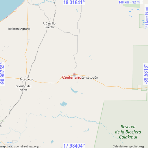
Centenario GPS coordinates[2]
18° 39' 5.508" North, 90° 17' 3.912" West
| Map corner | latitude | longitude |
|---|---|---|
| Upper-left | 19.31641°, | -90.98755° |
| Center: | 18.65153°, | -90.28442° |
| Lower-right: | 17.98404°, | -89.5813° |
| Map W x H: | 148.1×148.1 km | = 92×92mi |
| max Lat: | 32.7° ⇑70.8% North |
| Centenario: | 18.65153° |
| min Lat: | ⇓29.2% South 14.53588° |
| min Long | Centenario | max Long |
| -117.105° | -90.28442° | -86.73105° |
| W 97.3%⇐ | ⇒2.7% E |
Elevation
Elevation of Centenario is 71 m = 233 ft, and this is 1182.7 m = 3880 ft below average elevation for this country.
| Max E: |
3497 m = 11473 ft | 81.9% |
| Avg. | 1253.7 m = 4113 ft | |
| Centenario | 71 m = 233 ft | |
Min E: |
-1 m = -3 ft | 18.1% |
See also: Mexico elevation on elevation.city.
Geographical zone
Centenario is located in North Torrid zone (between Equator and Tropic of Cancer). Distance of this Northern Tropic circle is 532.1 km =330.6 mi to North.| Distance of | km | miles | from Centenario |
|---|---|---|---|
| North Pole | 7933.2 | 4929.5 | to North |
| Arctic Circle | 5327.3 | 3310.2 | to North |
| Tropic Cancer | 532.1 | 330.6 | to North |
| Equator | 2073.9 | 1288.7 | to South |


Nearby cities:
15 places around Centenario: (largest is in red/bold)
• Altamira de Zináparo
8.3 km =5.2 mi,  158°
158°
• Chan Laguna
20.5 km =12.7 mi, 157°
• Cinco de Febrero
43.2 km =26.8 mi,  301°
301°
• Constitución
15.9 km =9.9 mi,  99°
99°
• El Lechugal
15.7 km =9.8 mi,  249°
249°
• Justicia Social
11.3 km =7 mi, 253°
• La Libertad
25.8 km =16 mi, 249°
• Laguna Grande
18.7 km =11.6 mi,  358°
358°
• Matamoros
38.9 km =24.2 mi,  258°
258°
• Miguel Colorado
41.8 km =26 mi,  290°
290°
• Nuevo Conhuás
40.1 km =24.9 mi,  107°
107°
• Pablo García
15.7 km =9.8 mi, 103°
• Silvituc
1.8 km =1.1 mi,  129°
129°
• Xbonil
12.5 km =7.8 mi, 97°
• Yohaltún
40.3 km =25 mi, 355°
Sources, notices
• [Note1] Compared only with cities in Mexico existing in our database
• [Src1] Map data: © OpenStreetMap contributors (CC-BY-SA)
• [Src2] Other city data from geonames.org with taken over terms of usage.
• [Src3] Geographical zone / Annual Mean Temperature by Robert A. Rohde @ Wikipedia
