Luna geodata
Luna (Campeche) is a populated place; located in Mexico in America/Merida (GMT-6) time zone. With population of 701 people, there are 12418 cities with bigger population in this country. Compared to other cities in Mexico, 74.9% of cities are located further ↑North; 96.9% of cities are located further ←West and 79.9% of cities have higher elevation than Luna. Note1


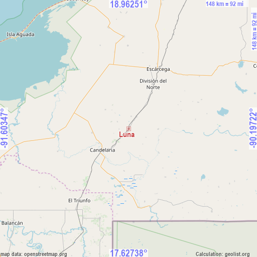
Luna GPS coordinates[2]
18° 17' 46.428" North, 90° 54' 1.224" West
| Map corner | latitude | longitude |
|---|---|---|
| Upper-left | 18.96251°, | -91.60347° |
| Center: | 18.29623°, | -90.90034° |
| Lower-right: | 17.62738°, | -90.19722° |
| Map W x H: | 148.5×148.5 km | = 92.3×92.3mi |
| max Lat: | 32.7° ⇑74.9% North |
| Luna: | 18.29623° |
| min Lat: | ⇓25.1% South 14.53588° |
| min Long | Luna | max Long |
| -117.105° | -90.90034° | -86.73105° |
| W 96.9%⇐ | ⇒3.1% E |
Elevation
Elevation of Luna is 96 m = 315 ft, and this is 1157.7 m = 3798 ft below average elevation for this country.
| Max E: |
3497 m = 11473 ft | 79.9% |
| Avg. | 1253.7 m = 4113 ft | |
| Luna | 96 m = 315 ft | |
Min E: |
-1 m = -3 ft | 20.1% |
See also: Mexico elevation on elevation.city.
Geographical zone
Luna is located in North Torrid zone (between Equator and Tropic of Cancer). Distance of this Northern Tropic circle is 571.6 km =355.2 mi to North.| Distance of | km | miles | from Luna |
|---|---|---|---|
| North Pole | 7972.7 | 4954 | to North |
| Arctic Circle | 5366.8 | 3334.8 | to North |
| Tropic Cancer | 571.6 | 355.2 | to North |
| Equator | 2034.4 | 1264.1 | to South |


Nearby cities:
15 places around Luna: (largest is in red/bold)
• Benito Juárez Uno
21.1 km =13.1 mi,  264°
264°
• Candelaria
19.6 km =12.2 mi,  231°
231°
• División del Norte
29.6 km =18.4 mi,  28°
28°
• Don Samuel
8.4 km =5.2 mi, 32°
• General Francisco J. Mújica
18.8 km =11.7 mi,  244°
244°
• Haro
20.1 km =12.5 mi, 34°
• La Victoria
21.8 km =13.5 mi,  353°
353°
• Mamantel
32.3 km =20.1 mi,  321°
321°
• Miguel Alemán
8.3 km =5.2 mi,  222°
222°
• Nueva Chontalpa
28.6 km =17.8 mi,  314°
314°
• Nueva Rosita
17.1 km =10.6 mi,  90°
90°
• Nuevo Progreso Dos
36.2 km =22.5 mi,  357°
357°
• Pablo García
24.4 km =15.2 mi,  186°
186°
• Pejelagarto
15.7 km =9.8 mi, 220°
• Venustiano Carranza
21.4 km =13.3 mi, 219°
Sources, notices
• [Note1] Compared only with cities in Mexico existing in our database
• [Src1] Map data: © OpenStreetMap contributors (CC-BY-SA)
• [Src2] Other city data from geonames.org with taken over terms of usage.
• [Src3] Geographical zone / Annual Mean Temperature by Robert A. Rohde @ Wikipedia
