Venustiano Carranza geodata
Venustiano Carranza (Campeche) is a populated place; located in Mexico in America/Merida (GMT-6) time zone. With population of 613 people, there are 14065 cities with bigger population in this country. Compared to other cities in Mexico, 76.9% of cities are located further ↑North; 96.8% of cities are located further ←West and 85% of cities have higher elevation than Venustiano Carranza. Note1


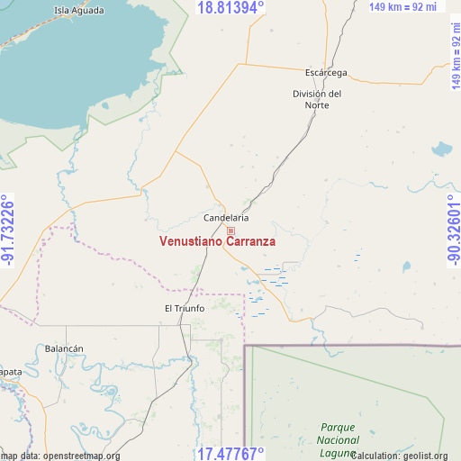
Venustiano Carranza GPS coordinates[2]
18° 8' 49.488" North, 91° 1' 44.868" West
| Map corner | latitude | longitude |
|---|---|---|
| Upper-left | 18.81394°, | -91.73226° |
| Center: | 18.14708°, | -91.02913° |
| Lower-right: | 17.47767°, | -90.32601° |
| Map W x H: | 148.6×148.6 km | = 92.3×92.3mi |
| max Lat: | 32.7° ⇑76.9% North |
| Venustiano Carranza: | 18.14708° |
| min Lat: | ⇓23.1% South 14.53588° |
| min Long | Venustiano Carr | max Long |
| -117.105° | -91.02913° | -86.73105° |
| W 96.8%⇐ | ⇒3.2% E |
Elevation
Elevation of Venustiano Carranza is 44 m = 144 ft, and this is 1209.7 m = 3969 ft below average elevation for this country.
| Max E: |
3497 m = 11473 ft | 85% |
| Avg. | 1253.7 m = 4113 ft | |
| Venustiano Carranza | 44 m = 144 ft | |
Min E: |
-1 m = -3 ft | 15% |
See also: Mexico elevation on elevation.city.
Geographical zone
Venustiano Carranza is located in North Torrid zone (between Equator and Tropic of Cancer). Distance of this Northern Tropic circle is 588.2 km =365.5 mi to North.| Distance of | km | miles | from Venustiano Carranza |
|---|---|---|---|
| North Pole | 7989.3 | 4964.3 | to North |
| Arctic Circle | 5383.4 | 3345.1 | to North |
| Tropic Cancer | 588.2 | 365.5 | to North |
| Equator | 2017.8 | 1253.8 | to South |


Nearby cities:
15 places around Venustiano Carranza: (largest is in red/bold)
• Benito Juárez Uno
16.2 km =10.1 mi,  332°
332°
• Candelaria
4.6 km =2.9 mi,  338°
338°
• Conquista Campesina
27.6 km =17.1 mi,  277°
277°
• Don Samuel
29.8 km =18.5 mi,  37°
37°
• El Naranjo
17.3 km =10.7 mi,  216°
216°
• El Pichi
25.6 km =15.9 mi,  177°
177°
• El Triunfo
29.1 km =18.1 mi,  210°
210°
• General Francisco J. Mújica
9.2 km =5.7 mi, 338°
• Luna
21.4 km =13.3 mi, 39°
• Lázaro Cárdenas
34.3 km =21.3 mi,  138°
138°
• Miguel Alemán
13.2 km =8.2 mi, 37°
• Miguel Hidalgo y Costilla
34.6 km =21.5 mi,  146°
146°
• Ojo de Agua
31.7 km =19.7 mi,  199°
199°
• Pablo García
13.3 km =8.3 mi,  125°
125°
• Pejelagarto
5.7 km =3.5 mi, 35°
Sources, notices
• [Note1] Compared only with cities in Mexico existing in our database
• [Src1] Map data: © OpenStreetMap contributors (CC-BY-SA)
• [Src2] Other city data from geonames.org with taken over terms of usage.
• [Src3] Geographical zone / Annual Mean Temperature by Robert A. Rohde @ Wikipedia
