Pablo García geodata
Pablo García (Campeche) is a populated place; located in Mexico in America/Merida (GMT-6) time zone. With population of 582 people, there are 14734 cities with bigger population in this country. Compared to other cities in Mexico, 77.8% of cities are located further ↑North; 96.9% of cities are located further ←West and 85% of cities have higher elevation than Pablo García. Note1


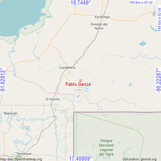
Pablo García GPS coordinates[2]
18° 4' 39.972" North, 90° 55' 33.564" West
| Map corner | latitude | longitude |
|---|---|---|
| Upper-left | 18.7449°, | -91.62912° |
| Center: | 18.07777°, | -90.92599° |
| Lower-right: | 17.40809°, | -90.22287° |
| Map W x H: | 148.6×148.6 km | = 92.3×92.3mi |
| max Lat: | 32.7° ⇑77.8% North |
| Pablo García: | 18.07777° |
| min Lat: | ⇓22.2% South 14.53588° |
| min Long | Pablo García | max Long |
| -117.105° | -90.92599° | -86.73105° |
| W 96.9%⇐ | ⇒3.1% E |
Elevation
Elevation of Pablo García is 44 m = 144 ft, and this is 1209.7 m = 3969 ft below average elevation for this country.
| Max E: |
3497 m = 11473 ft | 85% |
| Avg. | 1253.7 m = 4113 ft | |
| Pablo García | 44 m = 144 ft | |
Min E: |
-1 m = -3 ft | 15% |
See also: Mexico elevation on elevation.city.
Geographical zone
Pablo García is located in North Torrid zone (between Equator and Tropic of Cancer). Distance of this Northern Tropic circle is 595.9 km =370.3 mi to North.| Distance of | km | miles | from Pablo García |
|---|---|---|---|
| North Pole | 7997 | 4969.1 | to North |
| Arctic Circle | 5391.1 | 3349.9 | to North |
| Tropic Cancer | 595.9 | 370.3 | to North |
| Equator | 2010.1 | 1249 | to South |


Nearby cities:
15 places around Pablo García: (largest is in red/bold)
• Benito Juárez Uno
28.7 km =17.8 mi,  320°
320°
• Candelaria
17.4 km =10.8 mi,  313°
313°
• Cuauhtémoc
30.5 km =19 mi,  206°
206°
• El Mical
30.8 km =19.1 mi, 207°
• El Naranjo
22.1 km =13.7 mi,  253°
253°
• El Pichi
20.4 km =12.7 mi, 208°
• General Francisco J. Mújica
21.7 km =13.5 mi, 318°
• Las Golondrinas
24.2 km =15 mi,  150°
150°
• Luna
24.4 km =15.2 mi,  6°
6°
• Lázaro Cárdenas
21.5 km =13.4 mi, 145°
• Miguel Alemán
18.4 km =11.4 mi,  350°
350°
• Miguel Hidalgo y Costilla
22.6 km =14 mi,  158°
158°
• Pejelagarto
14.5 km =9 mi,  328°
328°
• Quetzalcóatl (Cuatro Poblados)
30.9 km =19.2 mi, 206°
• Venustiano Carranza
13.3 km =8.3 mi, 305°
Sources, notices
• [Note1] Compared only with cities in Mexico existing in our database
• [Src1] Map data: © OpenStreetMap contributors (CC-BY-SA)
• [Src2] Other city data from geonames.org with taken over terms of usage.
• [Src3] Geographical zone / Annual Mean Temperature by Robert A. Rohde @ Wikipedia
