San Juan del Río geodata
San Juan del Río (Guerrero) is a populated place; located in Mexico in America/Mexico_City (GMT-6) time zone. With population of 679 people, there are 12793 cities with bigger population in this country. Compared to other cities in Mexico, 88.5% of cities are located further ↑North; 63.3% of cities are located further →East and 66.9% of cities have higher elevation than San Juan del Río. Note1


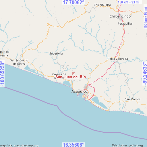
San Juan del Río GPS coordinates[2]
17° 1' 46.38" North, 99° 56' 58.02" West
| Map corner | latitude | longitude |
|---|---|---|
| Upper-left | 17.70062°, | -100.65258° |
| Center: | 17.02955°, | -99.94945° |
| Lower-right: | 16.35606°, | -99.24633° |
| Map W x H: | 149.5×149.5 km | = 92.9×92.9mi |
| max Lat: | 32.7° ⇑88.5% North |
| San Juan del Río: | 17.02955° |
| min Lat: | ⇓11.5% South 14.53588° |
| min Long | San Juan del R� | max Long |
| -117.105° | -99.94945° | -86.73105° |
| W 36.7%⇐ | ⇒63.3% E |
Elevation
Elevation of San Juan del Río is 588 m = 1929 ft, and this is 665.7 m = 2184 ft below average elevation for this country.
| Max E: |
3497 m = 11473 ft | 66.9% |
| Avg. | 1253.7 m = 4113 ft | |
| San Juan del Río | 588 m = 1929 ft | |
Min E: |
-1 m = -3 ft | 33.1% |
See also: Mexico elevation on elevation.city.
Geographical zone
San Juan del Río is located in North Torrid zone (between Equator and Tropic of Cancer). Distance of this Northern Tropic circle is 712.4 km =442.7 mi to North.| Distance of | km | miles | from San Juan del Río |
|---|---|---|---|
| North Pole | 8113.6 | 5041.6 | to North |
| Arctic Circle | 5507.7 | 3422.3 | to North |
| Tropic Cancer | 712.4 | 442.7 | to North |
| Equator | 1893.5 | 1176.6 | to South |


Nearby cities:
15 places around San Juan del Río: (largest is in red/bold)
• Agua Zarca
2.4 km =1.5 mi,  17°
17°
• Aguas Blancas
12.1 km =7.5 mi,  273°
273°
• Bajos del Ejido
8 km =5 mi,  197°
197°
• Cerrito de Oro
10.8 km =6.7 mi,  185°
185°
• Colonia San Isidro
6.2 km =3.9 mi,  171°
171°
• Ejido Viejo
9.1 km =5.7 mi,  177°
177°
• El Bordonal
9.6 km =6 mi,  229°
229°
• El Conchero
9.8 km =6.1 mi, 188°
• El Embarcadero
9.1 km =5.7 mi,  217°
217°
• Ocotillo
7.8 km =4.8 mi,  85°
85°
• Platanillo
5.7 km =3.5 mi,  46°
46°
• Pueblo Viejo
8.6 km =5.3 mi,  331°
331°
• Tixtlancingo
3.4 km =2.1 mi,  337°
337°
• Valle del Río
6.1 km =3.8 mi, 166°
• Yetla
7 km =4.3 mi,  235°
235°
Sources, notices
• [Note1] Compared only with cities in Mexico existing in our database
• [Src1] Map data: © OpenStreetMap contributors (CC-BY-SA)
• [Src2] Other city data from geonames.org with taken over terms of usage.
• [Src3] Geographical zone / Annual Mean Temperature by Robert A. Rohde @ Wikipedia
