Agua Zarca geodata
Agua Zarca (Guerrero) is a populated place; located in Mexico in America/Mexico_City (GMT-6) time zone. With population of 519 people, there are 16226 cities with bigger population in this country. Compared to other cities in Mexico, 88.2% of cities are located further ↑North; 63.2% of cities are located further →East and 66.6% of cities have higher elevation than Agua Zarca. Note1


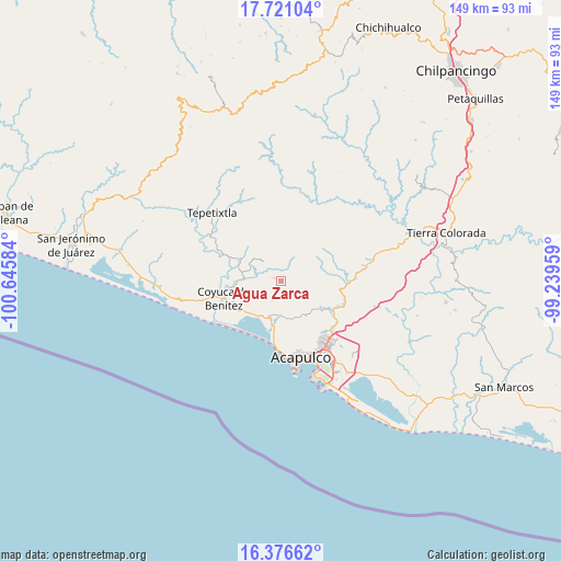
Agua Zarca GPS coordinates[2]
17° 3' 0.144" North, 99° 56' 33.756" West
| Map corner | latitude | longitude |
|---|---|---|
| Upper-left | 17.72104°, | -100.64584° |
| Center: | 17.05004°, | -99.94271° |
| Lower-right: | 16.37662°, | -99.23959° |
| Map W x H: | 149.5×149.5 km | = 92.9×92.9mi |
| max Lat: | 32.7° ⇑88.2% North |
| Agua Zarca: | 17.05004° |
| min Lat: | ⇓11.8% South 14.53588° |
| min Long | Agua Zarca | max Long |
| -117.105° | -99.94271° | -86.73105° |
| W 36.8%⇐ | ⇒63.2% E |
Elevation
Elevation of Agua Zarca is 604 m = 1982 ft, and this is 649.7 m = 2132 ft below average elevation for this country.
| Max E: |
3497 m = 11473 ft | 66.6% |
| Avg. | 1253.7 m = 4113 ft | |
| Agua Zarca | 604 m = 1982 ft | |
Min E: |
-1 m = -3 ft | 33.4% |
See also: Mexico elevation on elevation.city.
Geographical zone
Agua Zarca is located in North Torrid zone (between Equator and Tropic of Cancer). Distance of this Northern Tropic circle is 710.1 km =441.2 mi to North.| Distance of | km | miles | from Agua Zarca |
|---|---|---|---|
| North Pole | 8111.3 | 5040.1 | to North |
| Arctic Circle | 5505.4 | 3420.9 | to North |
| Tropic Cancer | 710.1 | 441.2 | to North |
| Equator | 1895.8 | 1178 | to South |


Nearby cities:
15 places around Agua Zarca: (largest is in red/bold)
• Aguas Blancas
12.9 km =8 mi,  263°
263°
• Bajos del Ejido
10.4 km =6.5 mi,  197°
197°
• Cerrito de Oro
13.1 km =8.1 mi,  187°
187°
• Colonia San Isidro
8.4 km =5.2 mi,  178°
178°
• Ejido Viejo
11.3 km =7 mi, 181°
• El Bordonal
11.7 km =7.3 mi,  222°
222°
• El Conchero
12.1 km =7.5 mi, 189°
• El Embarcadero
11.4 km =7.1 mi,  213°
213°
• Ocotillo
7.2 km =4.5 mi,  102°
102°
• Platanillo
3.8 km =2.4 mi,  64°
64°
• Pueblo Viejo
7.2 km =4.5 mi,  317°
317°
• San Juan del Río
2.4 km =1.5 mi, 197°
• Tixtlancingo
2.2 km =1.4 mi,  293°
293°
• Valle del Río
8.3 km =5.2 mi, 175°
• Yetla
9 km =5.6 mi,  225°
225°
Sources, notices
• [Note1] Compared only with cities in Mexico existing in our database
• [Src1] Map data: © OpenStreetMap contributors (CC-BY-SA)
• [Src2] Other city data from geonames.org with taken over terms of usage.
• [Src3] Geographical zone / Annual Mean Temperature by Robert A. Rohde @ Wikipedia
