Ocotillo geodata
Ocotillo (Guerrero) is a populated place; located in Mexico in America/Mexico_City (GMT-6) time zone. With population of 1,076 people, there are 8105 cities with bigger population in this country. Compared to other cities in Mexico, 88.4% of cities are located further ↑North; 62.4% of cities are located further →East and 64.6% of cities have higher elevation than Ocotillo. Note1


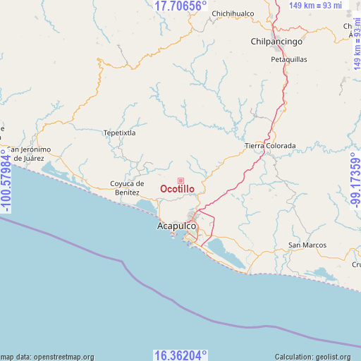
Ocotillo GPS coordinates[2]
17° 2' 7.836" North, 99° 52' 36.156" West
| Map corner | latitude | longitude |
|---|---|---|
| Upper-left | 17.70656°, | -100.57984° |
| Center: | 17.03551°, | -99.87671° |
| Lower-right: | 16.36204°, | -99.17359° |
| Map W x H: | 149.5×149.5 km | = 92.9×92.9mi |
| max Lat: | 32.7° ⇑88.4% North |
| Ocotillo: | 17.03551° |
| min Lat: | ⇓11.6% South 14.53588° |
| min Long | Ocotillo | max Long |
| -117.105° | -99.87671° | -86.73105° |
| W 37.6%⇐ | ⇒62.4% E |
Elevation
Elevation of Ocotillo is 713 m = 2339 ft, and this is 540.7 m = 1774 ft below average elevation for this country.
| Max E: |
3497 m = 11473 ft | 64.6% |
| Avg. | 1253.7 m = 4113 ft | |
| Ocotillo | 713 m = 2339 ft | |
Min E: |
-1 m = -3 ft | 35.4% |
See also: Mexico elevation on elevation.city.
Geographical zone
Ocotillo is located in North Torrid zone (between Equator and Tropic of Cancer). Distance of this Northern Tropic circle is 711.7 km =442.2 mi to North.| Distance of | km | miles | from Ocotillo |
|---|---|---|---|
| North Pole | 8112.9 | 5041.1 | to North |
| Arctic Circle | 5507 | 3421.9 | to North |
| Tropic Cancer | 711.7 | 442.2 | to North |
| Equator | 1894.2 | 1177 | to South |


Nearby cities:
15 places around Ocotillo: (largest is in red/bold)
• Agua Zarca
7.2 km =4.5 mi,  282°
282°
• Colonia San Isidro
9.7 km =6 mi,  225°
225°
• Colonia la Frontera Aguacatillo
11.8 km =7.3 mi,  137°
137°
• Ejido Viejo
12.2 km =7.6 mi,  217°
217°
• El Veladero (Veladero Morelos)
11.7 km =7.3 mi,  184°
184°
• Kilómetro 30
11.1 km =6.9 mi,  112°
112°
• Kilómetro 40
11.4 km =7.1 mi,  82°
82°
• La Providencia
9.3 km =5.8 mi,  42°
42°
• Lomas de San Juan
9.6 km =6 mi,  126°
126°
• Piedra Imán
10.9 km =6.8 mi,  65°
65°
• Platanillo
4.9 km =3 mi,  311°
311°
• San Juan del Río
7.8 km =4.8 mi,  265°
265°
• Texca
6.1 km =3.8 mi,  115°
115°
• Tixtlancingo
9.4 km =5.8 mi,  285°
285°
• Valle del Río
9.2 km =5.7 mi, 223°
Sources, notices
• [Note1] Compared only with cities in Mexico existing in our database
• [Src1] Map data: © OpenStreetMap contributors (CC-BY-SA)
• [Src2] Other city data from geonames.org with taken over terms of usage.
• [Src3] Geographical zone / Annual Mean Temperature by Robert A. Rohde @ Wikipedia
