Platanillo geodata
Platanillo (Guerrero) is a populated place; located in Mexico in America/Mexico_City (GMT-6) time zone. With population of 1,783 people, there are 4875 cities with bigger population in this country. Compared to other cities in Mexico, 88% of cities are located further ↑North; 62.7% of cities are located further →East and 66.5% of cities have higher elevation than Platanillo. Note1


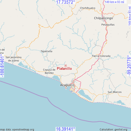
Platanillo GPS coordinates[2]
17° 3' 53.208" North, 99° 54' 39.168" West
| Map corner | latitude | longitude |
|---|---|---|
| Upper-left | 17.73572°, | -100.61401° |
| Center: | 17.06478°, | -99.91088° |
| Lower-right: | 16.39141°, | -99.20776° |
| Map W x H: | 149.5×149.5 km | = 92.9×92.9mi |
| max Lat: | 32.7° ⇑88% North |
| Platanillo: | 17.06478° |
| min Lat: | ⇓12% South 14.53588° |
| min Long | Platanillo | max Long |
| -117.105° | -99.91088° | -86.73105° |
| W 37.3%⇐ | ⇒62.7% E |
Elevation
Elevation of Platanillo is 612 m = 2008 ft, and this is 641.7 m = 2105 ft below average elevation for this country.
| Max E: |
3497 m = 11473 ft | 66.5% |
| Avg. | 1253.7 m = 4113 ft | |
| Platanillo | 612 m = 2008 ft | |
Min E: |
-1 m = -3 ft | 33.5% |
See also: Mexico elevation on elevation.city.
Geographical zone
Platanillo is located in North Torrid zone (between Equator and Tropic of Cancer). Distance of this Northern Tropic circle is 708.5 km =440.2 mi to North.| Distance of | km | miles | from Platanillo |
|---|---|---|---|
| North Pole | 8109.6 | 5039.1 | to North |
| Arctic Circle | 5503.7 | 3419.8 | to North |
| Tropic Cancer | 708.5 | 440.2 | to North |
| Equator | 1897.4 | 1179 | to South |


Nearby cities:
15 places around Platanillo: (largest is in red/bold)
• Agua Zarca
3.8 km =2.4 mi,  244°
244°
• Bajos del Ejido
13.2 km =8.2 mi,  209°
209°
• Colonia San Isidro
10.6 km =6.6 mi,  197°
197°
• Ejido Viejo
13.5 km =8.4 mi, 196°
• El Conchero
14.6 km =9.1 mi, 201°
• La Providencia
10.6 km =6.6 mi,  70°
70°
• Lomas de San Juan
14.5 km =9 mi,  128°
128°
• Ocotillo
4.9 km =3 mi, 131°
• Piedra Imán
13.6 km =8.5 mi,  84°
84°
• Pueblo Viejo
9 km =5.6 mi,  294°
294°
• San Juan del Río
5.7 km =3.5 mi,  226°
226°
• Texca
10.9 km =6.8 mi,  122°
122°
• Tixtlancingo
5.5 km =3.4 mi,  261°
261°
• Valle del Río
10.2 km =6.3 mi, 195°
• Yetla
12.6 km =7.8 mi, 231°
Sources, notices
• [Note1] Compared only with cities in Mexico existing in our database
• [Src1] Map data: © OpenStreetMap contributors (CC-BY-SA)
• [Src2] Other city data from geonames.org with taken over terms of usage.
• [Src3] Geographical zone / Annual Mean Temperature by Robert A. Rohde @ Wikipedia
