Pueblo Viejo geodata
Pueblo Viejo (Guerrero) is a populated place; located in Mexico in America/Mexico_City (GMT-6) time zone. With population of 1,539 people, there are 5613 cities with bigger population in this country. Compared to other cities in Mexico, 87.7% of cities are located further ↑North; 63.8% of cities are located further →East and 68.5% of cities have higher elevation than Pueblo Viejo. Note1


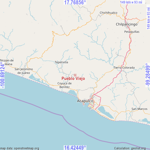
Pueblo Viejo GPS coordinates[2]
17° 5' 51.864" North, 99° 59' 17.196" West
| Map corner | latitude | longitude |
|---|---|---|
| Upper-left | 17.76856°, | -100.69124° |
| Center: | 17.09774°, | -99.98811° |
| Lower-right: | 16.42449°, | -99.28499° |
| Map W x H: | 149.4×149.4 km | = 92.8×92.8mi |
| max Lat: | 32.7° ⇑87.7% North |
| Pueblo Viejo: | 17.09774° |
| min Lat: | ⇓12.3% South 14.53588° |
| min Long | Pueblo Viejo | max Long |
| -117.105° | -99.98811° | -86.73105° |
| W 36.2%⇐ | ⇒63.8% E |
Elevation
Elevation of Pueblo Viejo is 496 m = 1627 ft, and this is 757.7 m = 2486 ft below average elevation for this country.
| Max E: |
3497 m = 11473 ft | 68.5% |
| Avg. | 1253.7 m = 4113 ft | |
| Pueblo Viejo | 496 m = 1627 ft | |
Min E: |
-1 m = -3 ft | 31.5% |
See also: Mexico elevation on elevation.city.
Geographical zone
Pueblo Viejo is located in North Torrid zone (between Equator and Tropic of Cancer). Distance of this Northern Tropic circle is 704.8 km =437.9 mi to North.| Distance of | km | miles | from Pueblo Viejo |
|---|---|---|---|
| North Pole | 8106 | 5036.8 | to North |
| Arctic Circle | 5500.1 | 3417.6 | to North |
| Tropic Cancer | 704.8 | 437.9 | to North |
| Equator | 1901.1 | 1181.3 | to South |


Nearby cities:
15 places around Pueblo Viejo: (largest is in red/bold)
• Agua Zarca
7.2 km =4.5 mi,  137°
137°
• Aguas Blancas
10.5 km =6.5 mi,  229°
229°
• Bajos del Ejido
15.3 km =9.5 mi,  173°
173°
• Carrera Larga
13.3 km =8.3 mi,  242°
242°
• Colonia San Isidro
14.6 km =9.1 mi,  160°
160°
• Coyuca de Benítez
14.4 km =8.9 mi, 226°
• El Bordonal
14.3 km =8.9 mi,  192°
192°
• El Embarcadero
14.9 km =9.3 mi, 185°
• Las Compuertas
11.1 km =6.9 mi,  348°
348°
• Ocotillo
13.7 km =8.5 mi,  120°
120°
• Platanillo
9 km =5.6 mi,  114°
114°
• San Juan del Río
8.6 km =5.3 mi,  151°
151°
• Tixtlancingo
5.2 km =3.2 mi, 147°
• Valle del Río
14.6 km =9.1 mi, 157°
• Yetla
11.7 km =7.3 mi, 187°
Sources, notices
• [Note1] Compared only with cities in Mexico existing in our database
• [Src1] Map data: © OpenStreetMap contributors (CC-BY-SA)
• [Src2] Other city data from geonames.org with taken over terms of usage.
• [Src3] Geographical zone / Annual Mean Temperature by Robert A. Rohde @ Wikipedia
