La Providencia geodata
La Providencia (Guerrero) is a populated place; located in Mexico in America/Mexico_City (GMT-6) time zone. With population of 966 people, there are 9007 cities with bigger population in this country. Compared to other cities in Mexico, 87.7% of cities are located further ↑North; 61.7% of cities are located further →East and 64.1% of cities have higher elevation than La Providencia. Note1


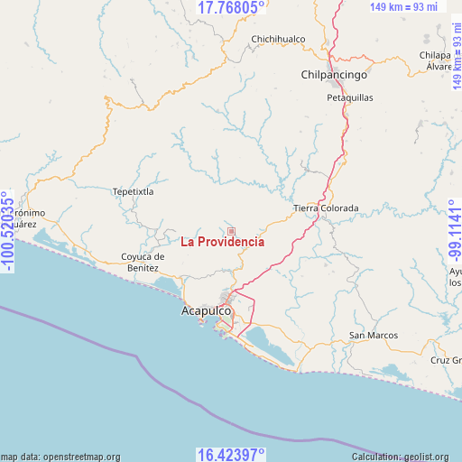
La Providencia GPS coordinates[2]
17° 5' 49.992" North, 99° 49' 1.992" West
| Map corner | latitude | longitude |
|---|---|---|
| Upper-left | 17.76805°, | -100.52035° |
| Center: | 17.09722°, | -99.81722° |
| Lower-right: | 16.42397°, | -99.1141° |
| Map W x H: | 149.4×149.5 km | = 92.8×92.9mi |
| max Lat: | 32.7° ⇑87.7% North |
| La Providencia: | 17.09722° |
| min Lat: | ⇓12.3% South 14.53588° |
| min Long | La Providencia | max Long |
| -117.105° | -99.81722° | -86.73105° |
| W 38.3%⇐ | ⇒61.7% E |
Elevation
Elevation of La Providencia is 746 m = 2448 ft, and this is 507.7 m = 1666 ft below average elevation for this country.
| Max E: |
3497 m = 11473 ft | 64.1% |
| Avg. | 1253.7 m = 4113 ft | |
| La Providencia | 746 m = 2448 ft | |
Min E: |
-1 m = -3 ft | 35.9% |
See also: Mexico elevation on elevation.city.
Geographical zone
La Providencia is located in North Torrid zone (between Equator and Tropic of Cancer). Distance of this Northern Tropic circle is 704.9 km =438 mi to North.| Distance of | km | miles | from La Providencia |
|---|---|---|---|
| North Pole | 8106 | 5036.8 | to North |
| Arctic Circle | 5500.1 | 3417.6 | to North |
| Tropic Cancer | 704.9 | 438 | to North |
| Equator | 1901 | 1181.2 | to South |


Nearby cities:
15 places around La Providencia: (largest is in red/bold)
• Agua Zarca
14.3 km =8.9 mi,  248°
248°
• Colonia la Frontera Aguacatillo
15.7 km =9.8 mi,  174°
174°
• Kilómetro 30
11.7 km =7.3 mi,  160°
160°
• Kilómetro 40
7.3 km =4.5 mi,  136°
136°
• Kilómetro 42 (Juan N. Álvarez)
7.7 km =4.8 mi,  127°
127°
• Lomas de San Juan
12.6 km =7.8 mi, 173°
• Ocotillo
9.3 km =5.8 mi,  222°
222°
• Pablo Galeana
13.8 km =8.6 mi,  68°
68°
• Piedra Imán
4.3 km =2.7 mi,  123°
123°
• Platanillo
10.6 km =6.6 mi, 250°
• Pueblo Madero (El Playón)
15.7 km =9.8 mi,  78°
78°
• San Juan del Río
15.9 km =9.9 mi,  241°
241°
• Texca
9.5 km =5.9 mi,  184°
184°
• Tixtlancingo
16 km =9.9 mi, 254°
• Xaltianguis
10.8 km =6.7 mi,  89°
89°
Sources, notices
• [Note1] Compared only with cities in Mexico existing in our database
• [Src1] Map data: © OpenStreetMap contributors (CC-BY-SA)
• [Src2] Other city data from geonames.org with taken over terms of usage.
• [Src3] Geographical zone / Annual Mean Temperature by Robert A. Rohde @ Wikipedia
