El Arenal geodata
El Arenal (Guerrero) is a populated place; located in Mexico in America/Mexico_City (GMT-6) time zone. With population of 1,000 people, there are 8715 cities with bigger population in this country. Compared to other cities in Mexico, 91.9% of cities are located further ↑North; 60.4% of cities are located further →East and 99.9% of cities have higher elevation than El Arenal. Note1


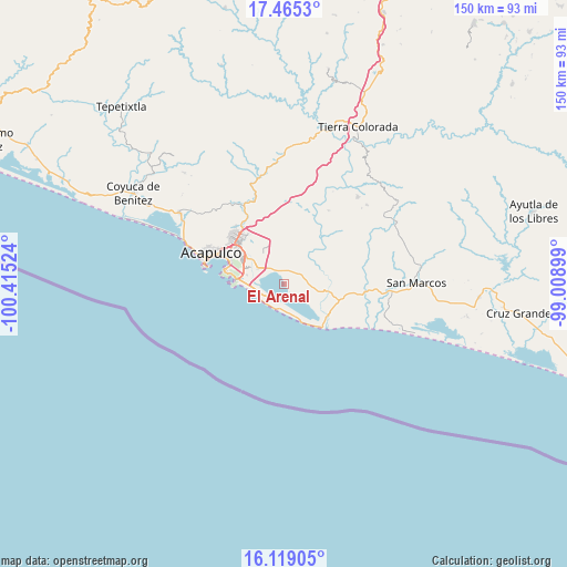
El Arenal GPS coordinates[2]
16° 47' 36.132" North, 99° 42' 43.596" West
| Map corner | latitude | longitude |
|---|---|---|
| Upper-left | 17.4653°, | -100.41524° |
| Center: | 16.79337°, | -99.71211° |
| Lower-right: | 16.11905°, | -99.00899° |
| Map W x H: | 149.7×149.7 km | = 93×93mi |
| max Lat: | 32.7° ⇑91.9% North |
| El Arenal: | 16.79337° |
| min Lat: | ⇓8.1% South 14.53588° |
| min Long | El Arenal | max Long |
| -117.105° | -99.71211° | -86.73105° |
| W 39.6%⇐ | ⇒60.4% E |
Elevation
Elevation of El Arenal is 2 m = 7 ft, and this is 1251.7 m = 4107 ft below average elevation for this country.
| Max E: |
3497 m = 11473 ft | 99.9% |
| Avg. | 1253.7 m = 4113 ft | |
| El Arenal | 2 m = 7 ft | |
Min E: |
-1 m = -3 ft | 0.1% |
See also: Mexico elevation on elevation.city.
Geographical zone
El Arenal is located in North Torrid zone (between Equator and Tropic of Cancer). Distance of this Northern Tropic circle is 738.7 km =459 mi to North.| Distance of | km | miles | from El Arenal |
|---|---|---|---|
| North Pole | 8139.8 | 5057.8 | to North |
| Arctic Circle | 5533.9 | 3438.6 | to North |
| Tropic Cancer | 738.7 | 459 | to North |
| Equator | 1867.2 | 1160.2 | to South |


Nearby cities:
15 places around El Arenal: (largest is in red/bold)
• 10 de Abril
5 km =3.1 mi,  322°
322°
• Aguas Calientes
9.4 km =5.8 mi,  54°
54°
• Amatillo
5.7 km =3.5 mi,  58°
58°
• Cerro de Piedra
8.9 km =5.5 mi,  102°
102°
• El Bejuco
3.5 km =2.2 mi,  8°
8°
• El Metlapil
6.6 km =4.1 mi, 323°
• El Salto
9.7 km =6 mi, 324°
• La Estación
5.6 km =3.5 mi,  121°
121°
• Nicolás Bravo (Zanja del Teniente)
5.8 km =3.6 mi, 319°
• Oaxaquillas
6.8 km =4.2 mi, 59°
• San Antonio
5.9 km =3.7 mi,  81°
81°
• San Isidro Gallinero (El Gallinero)
9.8 km =6.1 mi,  358°
358°
• San Pedro Cacahuatepec
5.2 km =3.2 mi, 62°
• San Pedro las Playas
3.9 km =2.4 mi,  327°
327°
• Tres Palos
8.1 km =5 mi,  299°
299°
Sources, notices
• [Note1] Compared only with cities in Mexico existing in our database
• [Src1] Map data: © OpenStreetMap contributors (CC-BY-SA)
• [Src2] Other city data from geonames.org with taken over terms of usage.
• [Src3] Geographical zone / Annual Mean Temperature by Robert A. Rohde @ Wikipedia
