Tepehuisco geodata
Tepehuisco (Guerrero) is a populated place; located in Mexico in America/Mexico_City (GMT-6) time zone. With population of 716 people, there are 12166 cities with bigger population in this country. Compared to other cities in Mexico, 82.2% of cities are located further ↑North; 53.6% of cities are located further →East and 61.2% of cities have lower elevation than Tepehuisco. Note1


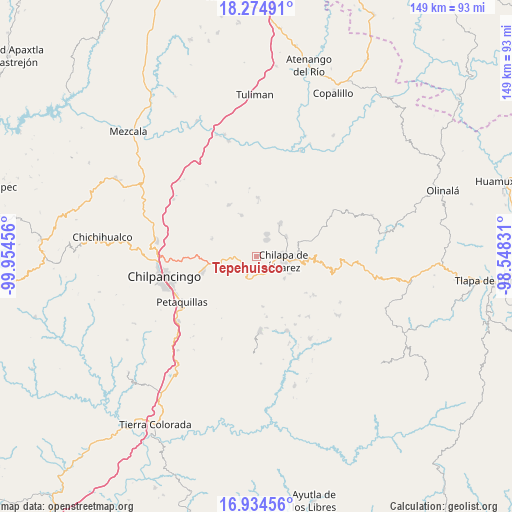
Tepehuisco GPS coordinates[2]
17° 36' 21.528" North, 99° 15' 5.148" West
| Map corner | latitude | longitude |
|---|---|---|
| Upper-left | 18.27491°, | -99.95456° |
| Center: | 17.60598°, | -99.25143° |
| Lower-right: | 16.93456°, | -98.54831° |
| Map W x H: | 149×149 km | = 92.6×92.6mi |
| max Lat: | 32.7° ⇑82.2% North |
| Tepehuisco: | 17.60598° |
| min Lat: | ⇓17.8% South 14.53588° |
| min Long | Tepehuisco | max Long |
| -117.105° | -99.25143° | -86.73105° |
| W 46.4%⇐ | ⇒53.6% E |
Elevation
Elevation of Tepehuisco is 1747 m = 5732 ft, and this is 493.3 m = 1618 ft above average elevation for this country.
| Max E: |
3497 m = 11473 ft | 38.8% |
| Tepehuisco | 1747 m 5732 ft | |
| Avg. | 1253.7 m = 4113 ft | |
Min E: |
-1 m = -3 ft | 61.2% |
See also: Mexico elevation on elevation.city.
Geographical zone
Tepehuisco is located in North Torrid zone (between Equator and Tropic of Cancer). Distance of this Northern Tropic circle is 648.3 km =402.8 mi to North.| Distance of | km | miles | from Tepehuisco |
|---|---|---|---|
| North Pole | 8049.5 | 5001.7 | to North |
| Arctic Circle | 5443.6 | 3382.5 | to North |
| Tropic Cancer | 648.3 | 402.8 | to North |
| Equator | 1957.6 | 1216.4 | to South |


Nearby cities:
15 places around Tepehuisco: (largest is in red/bold)
• Ahuihuiyuco
3.7 km =2.3 mi,  44°
44°
• Almolonga
5.8 km =3.6 mi,  307°
307°
• Amate Amarillo
5.4 km =3.4 mi,  113°
113°
• Ayahualco
7.2 km =4.5 mi,  74°
74°
• Chilacachapa
6.2 km =3.9 mi,  207°
207°
• Coaquimixco
3.4 km =2.1 mi,  150°
150°
• Cuadrilla Nueva
5 km =3.1 mi,  129°
129°
• La Mohonera
6.3 km =3.9 mi,  55°
55°
• Lodo Grande
4.2 km =2.6 mi,  84°
84°
• Mazatepec
7.4 km =4.6 mi,  29°
29°
• Pochahuizco
7.2 km =4.5 mi,  24°
24°
• Santa Ana
4.7 km =2.9 mi,  138°
138°
• Tepozcuautla
3.1 km =1.9 mi,  54°
54°
• Topiltepec
5.8 km =3.6 mi, 31°
• Zoquiapa
7.3 km =4.5 mi,  201°
201°
Sources, notices
• [Note1] Compared only with cities in Mexico existing in our database
• [Src1] Map data: © OpenStreetMap contributors (CC-BY-SA)
• [Src2] Other city data from geonames.org with taken over terms of usage.
• [Src3] Geographical zone / Annual Mean Temperature by Robert A. Rohde @ Wikipedia
