Tepozcuautla geodata
Tepozcuautla (Guerrero) is a populated place; located in Mexico in America/Mexico_City (GMT-6) time zone. With population of 1,254 people, there are 6906 cities with bigger population in this country. Compared to other cities in Mexico, 82% of cities are located further ↑North; 53.3% of cities are located further →East and 57.4% of cities have lower elevation than Tepozcuautla. Note1


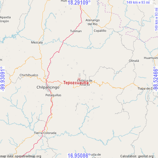
Tepozcuautla GPS coordinates[2]
17° 37' 19.992" North, 99° 13' 40.008" West
| Map corner | latitude | longitude |
|---|---|---|
| Upper-left | 18.29109°, | -99.93091° |
| Center: | 17.62222°, | -99.22778° |
| Lower-right: | 16.95086°, | -98.52466° |
| Map W x H: | 149×149 km | = 92.6×92.6mi |
| max Lat: | 32.7° ⇑82% North |
| Tepozcuautla: | 17.62222° |
| min Lat: | ⇓18% South 14.53588° |
| min Long | Tepozcuautla | max Long |
| -117.105° | -99.22778° | -86.73105° |
| W 46.7%⇐ | ⇒53.3% E |
Elevation
Elevation of Tepozcuautla is 1672 m = 5486 ft, and this is 418.3 m = 1372 ft above average elevation for this country.
| Max E: |
3497 m = 11473 ft | 42.6% |
| Tepozcuautla | 1672 m 5486 ft | |
| Avg. | 1253.7 m = 4113 ft | |
Min E: |
-1 m = -3 ft | 57.4% |
See also: Mexico elevation on elevation.city.
Geographical zone
Tepozcuautla is located in North Torrid zone (between Equator and Tropic of Cancer). Distance of this Northern Tropic circle is 646.5 km =401.7 mi to North.| Distance of | km | miles | from Tepozcuautla |
|---|---|---|---|
| North Pole | 8047.7 | 5000.6 | to North |
| Arctic Circle | 5441.8 | 3381.4 | to North |
| Tropic Cancer | 646.5 | 401.7 | to North |
| Equator | 1959.4 | 1217.5 | to South |


Nearby cities:
15 places around Tepozcuautla: (largest is in red/bold)
• Ahuihuiyuco
0.8 km =0.5 mi,  2°
2°
• Almolonga
7.3 km =4.5 mi,  284°
284°
• Amate Amarillo
4.7 km =2.9 mi,  147°
147°
• Ayahualco
4.4 km =2.7 mi,  87°
87°
• Chilapa de Álvarez
6.3 km =3.9 mi,  114°
114°
• Coaquimixco
4.8 km =3 mi,  189°
189°
• Cuadrilla Nueva
5.2 km =3.2 mi,  164°
164°
• La Mohonera
3.3 km =2.1 mi,  56°
56°
• Lodo Grande
2.2 km =1.4 mi,  129°
129°
• Los Magueyes
6 km =3.7 mi,  83°
83°
• Mazatepec
4.8 km =3 mi,  13°
13°
• Pochahuizco
4.8 km =3 mi, 6°
• Santa Ana
5.3 km =3.3 mi,  173°
173°
• Tepehuisco
3.1 km =1.9 mi,  234°
234°
• Topiltepec
3.2 km =2 mi, 10°
Sources, notices
• [Note1] Compared only with cities in Mexico existing in our database
• [Src1] Map data: © OpenStreetMap contributors (CC-BY-SA)
• [Src2] Other city data from geonames.org with taken over terms of usage.
• [Src3] Geographical zone / Annual Mean Temperature by Robert A. Rohde @ Wikipedia
