Lodo Grande geodata
Lodo Grande (Guerrero) is a populated place; located in Mexico in America/Mexico_City (GMT-6) time zone. With population of 1,035 people, there are 8423 cities with bigger population in this country. Compared to other cities in Mexico, 82.1% of cities are located further ↑North; 53% of cities are located further →East and 52.2% of cities have lower elevation than Lodo Grande. Note1


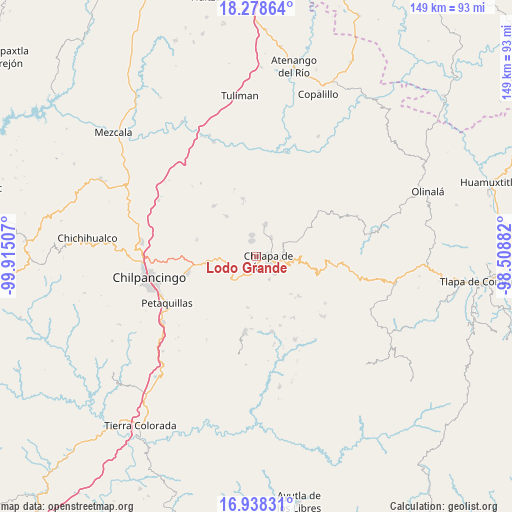
Lodo Grande GPS coordinates[2]
17° 36' 34.992" North, 99° 12' 42.984" West
| Map corner | latitude | longitude |
|---|---|---|
| Upper-left | 18.27864°, | -99.91507° |
| Center: | 17.60972°, | -99.21194° |
| Lower-right: | 16.93831°, | -98.50882° |
| Map W x H: | 149×149 km | = 92.6×92.6mi |
| max Lat: | 32.7° ⇑82.1% North |
| Lodo Grande: | 17.60972° |
| min Lat: | ⇓17.9% South 14.53588° |
| min Long | Lodo Grande | max Long |
| -117.105° | -99.21194° | -86.73105° |
| W 47%⇐ | ⇒53% E |
Elevation
Elevation of Lodo Grande is 1528 m = 5013 ft, and this is 274.3 m = 900 ft above average elevation for this country.
| Max E: |
3497 m = 11473 ft | 47.8% |
| Lodo Grande | 1528 m 5013 ft | |
| Avg. | 1253.7 m = 4113 ft | |
Min E: |
-1 m = -3 ft | 52.2% |
See also: Mexico elevation on elevation.city.
Geographical zone
Lodo Grande is located in North Torrid zone (between Equator and Tropic of Cancer). Distance of this Northern Tropic circle is 647.9 km =402.6 mi to North.| Distance of | km | miles | from Lodo Grande |
|---|---|---|---|
| North Pole | 8049 | 5001.4 | to North |
| Arctic Circle | 5443.2 | 3382.2 | to North |
| Tropic Cancer | 647.9 | 402.6 | to North |
| Equator | 1958 | 1216.6 | to South |


Nearby cities:
15 places around Lodo Grande: (largest is in red/bold)
• Ahuihuiyuco
2.7 km =1.7 mi,  323°
323°
• Amate Amarillo
2.7 km =1.7 mi,  162°
162°
• Ayahualco
3.1 km =1.9 mi,  60°
60°
• Chilapa de Álvarez
4.2 km =2.6 mi,  106°
106°
• Coaquimixco
4.2 km =2.6 mi,  216°
216°
• Cuadrilla Nueva
3.6 km =2.2 mi,  185°
185°
• La Mohonera
3.4 km =2.1 mi,  17°
17°
• Los Magueyes
4.7 km =2.9 mi, 64°
• Mazatepec
6.1 km =3.8 mi,  354°
354°
• Ocuituco (Acuituco)
5.8 km =3.6 mi,  152°
152°
• Santa Ana
4.1 km =2.5 mi,  195°
195°
• Tepehuisco
4.2 km =2.6 mi,  264°
264°
• Tepozcuautla
2.2 km =1.4 mi,  309°
309°
• Tlacoaxtla
6.2 km =3.9 mi,  169°
169°
• Topiltepec
4.7 km =2.9 mi, 346°
Sources, notices
• [Note1] Compared only with cities in Mexico existing in our database
• [Src1] Map data: © OpenStreetMap contributors (CC-BY-SA)
• [Src2] Other city data from geonames.org with taken over terms of usage.
• [Src3] Geographical zone / Annual Mean Temperature by Robert A. Rohde @ Wikipedia
