Almolonga geodata
Almolonga (Guerrero) is a populated place; located in Mexico in America/Mexico_City (GMT-6) time zone. With population of 1,230 people, there are 7057 cities with bigger population in this country. Compared to other cities in Mexico, 81.9% of cities are located further ↑North; 54.1% of cities are located further →East and 60% of cities have lower elevation than Almolonga. Note1


Almolonga GPS coordinates[2]
17° 38' 17.736" North, 99° 17' 42.072" West
| Map corner | latitude | longitude |
|---|---|---|
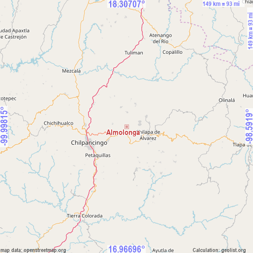
| Upper-left | 18.30707°, | -99.99815° |
| Center: | 17.63826°, | -99.29502° |
| Lower-right: | 16.96696°, | -98.5919° |
| Map W x H: | 149×149 km | = 92.6×92.6mi |
| max Lat: | 32.7° ⇑81.9% North |
| Almolonga: | 17.63826° |
| min Lat: | ⇓18.1% South 14.53588° |
| min Long | Almolonga | max Long |
| -117.105° | -99.29502° | -86.73105° |
| W 45.9%⇐ | ⇒54.1% E |
Elevation
Elevation of Almolonga is 1725 m = 5659 ft, and this is 471.3 m = 1546 ft above average elevation for this country.
| Max E: |
3497 m = 11473 ft | 40% |
| Almolonga | 1725 m 5659 ft | |
| Avg. | 1253.7 m = 4113 ft | |
Min E: |
-1 m = -3 ft | 60% |
See also: Mexico elevation on elevation.city.
Geographical zone
Almolonga is located in North Torrid zone (between Equator and Tropic of Cancer). Distance of this Northern Tropic circle is 644.7 km =400.6 mi to North.| Distance of | km | miles | from Almolonga |
|---|---|---|---|
| North Pole | 8045.9 | 4999.5 | to North |
| Arctic Circle | 5440 | 3380.3 | to North |
| Tropic Cancer | 644.7 | 400.6 | to North |
| Equator | 1961.2 | 1218.6 | to South |


Nearby cities:
15 places around Almolonga: (largest is in red/bold)
• Acatempa
7.6 km =4.7 mi,  274°
274°
• Ahuihuiyuco
7.2 km =4.5 mi,  97°
97°
• Atliaca
8.6 km =5.3 mi,  280°
280°
• Ayotzinapa
10.5 km =6.5 mi,  34°
34°
• Chilacachapa
9.3 km =5.8 mi,  169°
169°
• Coaquimixco
9.1 km =5.7 mi,  136°
136°
• Hueyitlalpan
4.1 km =2.5 mi,  359°
359°
• La Mohonera
9.8 km =6.1 mi,  89°
89°
• Lodo Grande
9.4 km =5.8 mi,  109°
109°
• Mazatepec
8.7 km =5.4 mi,  70°
70°
• Pochahuizco
8.2 km =5.1 mi, 68°
• Tepehuisco
5.8 km =3.6 mi,  127°
127°
• Tepozcuautla
7.3 km =4.5 mi, 104°
• Topiltepec
7.8 km =4.8 mi,  80°
80°
• Zotoltitlán
8.5 km =5.3 mi,  2°
2°
Sources, notices
• [Note1] Compared only with cities in Mexico existing in our database
• [Src1] Map data: © OpenStreetMap contributors (CC-BY-SA)
• [Src2] Other city data from geonames.org with taken over terms of usage.
• [Src3] Geographical zone / Annual Mean Temperature by Robert A. Rohde @ Wikipedia
