Tecoanapa geodata
Tecoanapa (Guerrero) is a seat of a second-order administrative division; located in Mexico in America/Mexico_City (GMT-6) time zone. With population of 4,268 people, there are 2149 cities with bigger population in this country. Compared to other cities in Mexico, 89% of cities are located further ↑North; 53.8% of cities are located further →East and 69.7% of cities have higher elevation than Tecoanapa. Note1


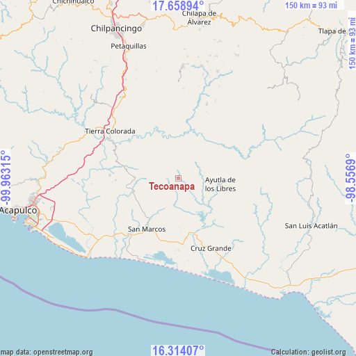
Tecoanapa GPS coordinates[2]
16° 59' 15.756" North, 99° 15' 36.072" West
| Map corner | latitude | longitude |
|---|---|---|
| Upper-left | 17.65894°, | -99.96315° |
| Center: | 16.98771°, | -99.26002° |
| Lower-right: | 16.31407°, | -98.5569° |
| Map W x H: | 149.5×149.5 km | = 92.9×92.9mi |
| max Lat: | 32.7° ⇑89% North |
| Tecoanapa: | 16.98771° |
| min Lat: | ⇓11% South 14.53588° |
| min Long | Tecoanapa | max Long |
| -117.105° | -99.26002° | -86.73105° |
| W 46.2%⇐ | ⇒53.8% E |
Elevation
Elevation of Tecoanapa is 432 m = 1417 ft, and this is 821.7 m = 2696 ft below average elevation for this country.
| Max E: |
3497 m = 11473 ft | 69.7% |
| Avg. | 1253.7 m = 4113 ft | |
| Tecoanapa | 432 m = 1417 ft | |
Min E: |
-1 m = -3 ft | 30.3% |
See also: Mexico elevation on elevation.city.
Geographical zone
Tecoanapa is located in North Torrid zone (between Equator and Tropic of Cancer). Distance of this Northern Tropic circle is 717.1 km =445.6 mi to North.| Distance of | km | miles | from Tecoanapa |
|---|---|---|---|
| North Pole | 8118.2 | 5044.4 | to North |
| Arctic Circle | 5512.3 | 3425.2 | to North |
| Tropic Cancer | 717.1 | 445.6 | to North |
| Equator | 1888.9 | 1173.7 | to South |


Nearby cities:
15 places around Tecoanapa: (largest is in red/bold)
• Buenavista de Allende
5.2 km =3.2 mi,  73°
73°
• Colotepec
7.8 km =4.8 mi,  40°
40°
• El Carrizo
8.2 km =5.1 mi,  149°
149°
• El Charco
8.3 km =5.2 mi,  347°
347°
• El Guayabo
7.8 km =4.8 mi,  133°
133°
• El Pericón
7 km =4.3 mi,  263°
263°
• Huamuchapa
8 km =5 mi,  231°
231°
• Lagunillas
7.6 km =4.7 mi, 66°
• Las Ánimas
6.6 km =4.1 mi, 255°
• Los Saucitos
4.3 km =2.7 mi,  266°
266°
• Los Tepetates
8 km =5 mi,  9°
9°
• Mecatepec
2.4 km =1.5 mi,  100°
100°
• Parota Seca
5.3 km =3.3 mi,  179°
179°
• San Francisco
3.2 km =2 mi,  309°
309°
• Tecuantepec
1.9 km =1.2 mi, 41°
Sources, notices
• [Note1] Compared only with cities in Mexico existing in our database
• [Src1] Map data: © OpenStreetMap contributors (CC-BY-SA)
• [Src2] Other city data from geonames.org with taken over terms of usage.
• [Src3] Geographical zone / Annual Mean Temperature by Robert A. Rohde @ Wikipedia
