El Tecorral geodata
El Tecorral (Guerrero) is a populated place; located in Mexico in America/Mexico_City (GMT-6) time zone. With population of 651 people, there are 13306 cities with bigger population in this country. Compared to other cities in Mexico, 90.3% of cities are located further ↑North; 53.9% of cities are located further →East and 71.4% of cities have higher elevation than El Tecorral. Note1


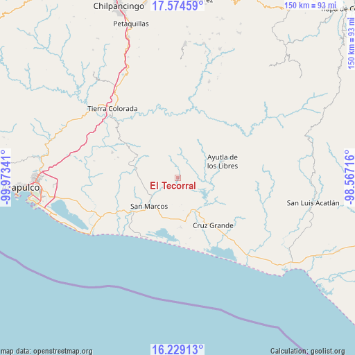
El Tecorral GPS coordinates[2]
16° 54' 11.016" North, 99° 16' 13.008" West
| Map corner | latitude | longitude |
|---|---|---|
| Upper-left | 17.57459°, | -99.97341° |
| Center: | 16.90306°, | -99.27028° |
| Lower-right: | 16.22913°, | -98.56716° |
| Map W x H: | 149.6×149.6 km | = 93×93mi |
| max Lat: | 32.7° ⇑90.3% North |
| El Tecorral: | 16.90306° |
| min Lat: | ⇓9.7% South 14.53588° |
| min Long | El Tecorral | max Long |
| -117.105° | -99.27028° | -86.73105° |
| W 46.1%⇐ | ⇒53.9% E |
Elevation
Elevation of El Tecorral is 352 m = 1155 ft, and this is 901.7 m = 2958 ft below average elevation for this country.
| Max E: |
3497 m = 11473 ft | 71.4% |
| Avg. | 1253.7 m = 4113 ft | |
| El Tecorral | 352 m = 1155 ft | |
Min E: |
-1 m = -3 ft | 28.6% |
See also: Mexico elevation on elevation.city.
Geographical zone
El Tecorral is located in North Torrid zone (between Equator and Tropic of Cancer). Distance of this Northern Tropic circle is 726.5 km =451.4 mi to North.| Distance of | km | miles | from El Tecorral |
|---|---|---|---|
| North Pole | 8127.6 | 5050.3 | to North |
| Arctic Circle | 5521.7 | 3431 | to North |
| Tropic Cancer | 726.5 | 451.4 | to North |
| Equator | 1879.4 | 1167.8 | to South |


Nearby cities:
15 places around El Tecorral: (largest is in red/bold)
• El Amatal
5.3 km =3.3 mi,  237°
237°
• El Carrizo
5.7 km =3.5 mi,  65°
65°
• El Guayabo
7.9 km =4.9 mi,  59°
59°
• El Pericón
10.4 km =6.5 mi,  325°
325°
• Huamuchapa
6.8 km =4.2 mi,  311°
311°
• Las Ánimas
9.4 km =5.8 mi, 325°
• Los Saucitos
9.7 km =6 mi,  340°
340°
• Mecatepec
9.6 km =6 mi,  21°
21°
• Parota Seca
4.3 km =2.7 mi, 15°
• Rancho Viejo
4.7 km =2.9 mi,  205°
205°
• Santa Elena Guerrero
7.9 km =4.9 mi, 239°
• Santa Elena de la Villa
6.4 km =4 mi, 238°
• Tecoanapa
9.5 km =5.9 mi,  6°
6°
• Tecuantepec
11.1 km =6.9 mi, 12°
• Villa Hermosa
7.5 km =4.7 mi,  301°
301°
Sources, notices
• [Note1] Compared only with cities in Mexico existing in our database
• [Src1] Map data: © OpenStreetMap contributors (CC-BY-SA)
• [Src2] Other city data from geonames.org with taken over terms of usage.
• [Src3] Geographical zone / Annual Mean Temperature by Robert A. Rohde @ Wikipedia
