Parota Seca geodata
Parota Seca (Guerrero) is a populated place; located in Mexico in America/Mexico_City (GMT-6) time zone. With population of 981 people, there are 8862 cities with bigger population in this country. Compared to other cities in Mexico, 89.7% of cities are located further ↑North; 53.7% of cities are located further →East and 68.5% of cities have higher elevation than Parota Seca. Note1


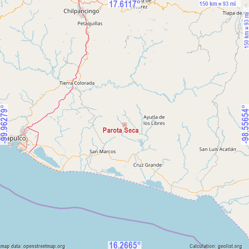
Parota Seca GPS coordinates[2]
16° 56' 25.08" North, 99° 15' 34.776" West
| Map corner | latitude | longitude |
|---|---|---|
| Upper-left | 17.6117°, | -99.96279° |
| Center: | 16.9403°, | -99.25966° |
| Lower-right: | 16.2665°, | -98.55654° |
| Map W x H: | 149.6×149.6 km | = 93×93mi |
| max Lat: | 32.7° ⇑89.7% North |
| Parota Seca: | 16.9403° |
| min Lat: | ⇓10.3% South 14.53588° |
| min Long | Parota Seca | max Long |
| -117.105° | -99.25966° | -86.73105° |
| W 46.3%⇐ | ⇒53.7% E |
Elevation
Elevation of Parota Seca is 499 m = 1637 ft, and this is 754.7 m = 2476 ft below average elevation for this country.
| Max E: |
3497 m = 11473 ft | 68.5% |
| Avg. | 1253.7 m = 4113 ft | |
| Parota Seca | 499 m = 1637 ft | |
Min E: |
-1 m = -3 ft | 31.5% |
See also: Mexico elevation on elevation.city.
Geographical zone
Parota Seca is located in North Torrid zone (between Equator and Tropic of Cancer). Distance of this Northern Tropic circle is 722.3 km =448.8 mi to North.| Distance of | km | miles | from Parota Seca |
|---|---|---|---|
| North Pole | 8123.5 | 5047.7 | to North |
| Arctic Circle | 5517.6 | 3428.5 | to North |
| Tropic Cancer | 722.3 | 448.8 | to North |
| Equator | 1883.6 | 1170.4 | to South |


Nearby cities:
15 places around Parota Seca: (largest is in red/bold)
• Buenavista de Allende
8.3 km =5.2 mi,  36°
36°
• El Amatal
8.9 km =5.5 mi,  218°
218°
• El Carrizo
4.4 km =2.7 mi,  113°
113°
• El Guayabo
5.6 km =3.5 mi,  90°
90°
• El Pericón
8.3 km =5.2 mi,  302°
302°
• El Tecorral
4.3 km =2.7 mi,  195°
195°
• Huamuchapa
6.3 km =3.9 mi,  273°
273°
• Las Ánimas
7.3 km =4.5 mi, 299°
• Los Saucitos
6.6 km =4.1 mi,  319°
319°
• Mecatepec
5.4 km =3.4 mi,  26°
26°
• Rancho Viejo
9 km =5.6 mi, 200°
• San Francisco
7.7 km =4.8 mi,  341°
341°
• Tecoanapa
5.3 km =3.3 mi,  359°
359°
• Tecuantepec
6.8 km =4.2 mi,  10°
10°
• Villa Hermosa
7.5 km =4.7 mi, 268°
Sources, notices
• [Note1] Compared only with cities in Mexico existing in our database
• [Src1] Map data: © OpenStreetMap contributors (CC-BY-SA)
• [Src2] Other city data from geonames.org with taken over terms of usage.
• [Src3] Geographical zone / Annual Mean Temperature by Robert A. Rohde @ Wikipedia
