El Guayabo geodata
El Guayabo (Guerrero) is a populated place; located in Mexico in America/Mexico_City (GMT-6) time zone. With population of 696 people, there are 12503 cities with bigger population in this country. Compared to other cities in Mexico, 89.7% of cities are located further ↑North; 52.9% of cities are located further →East and 72.5% of cities have higher elevation than El Guayabo. Note1


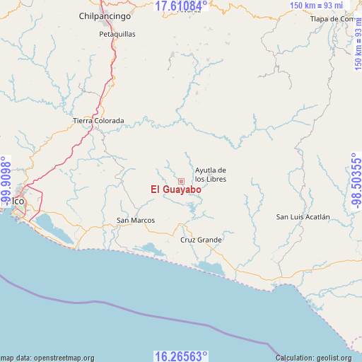
El Guayabo GPS coordinates[2]
16° 56' 21.984" North, 99° 12' 24.012" West
| Map corner | latitude | longitude |
|---|---|---|
| Upper-left | 17.61084°, | -99.9098° |
| Center: | 16.93944°, | -99.20667° |
| Lower-right: | 16.26563°, | -98.50355° |
| Map W x H: | 149.6×149.6 km | = 93×93mi |
| max Lat: | 32.7° ⇑89.7% North |
| El Guayabo: | 16.93944° |
| min Lat: | ⇓10.3% South 14.53588° |
| min Long | El Guayabo | max Long |
| -117.105° | -99.20667° | -86.73105° |
| W 47.1%⇐ | ⇒52.9% E |
Elevation
Elevation of El Guayabo is 313 m = 1027 ft, and this is 940.7 m = 3086 ft below average elevation for this country.
| Max E: |
3497 m = 11473 ft | 72.5% |
| Avg. | 1253.7 m = 4113 ft | |
| El Guayabo | 313 m = 1027 ft | |
Min E: |
-1 m = -3 ft | 27.5% |
See also: Mexico elevation on elevation.city.
Geographical zone
El Guayabo is located in North Torrid zone (between Equator and Tropic of Cancer). Distance of this Northern Tropic circle is 722.4 km =448.9 mi to North.| Distance of | km | miles | from El Guayabo |
|---|---|---|---|
| North Pole | 8123.6 | 5047.8 | to North |
| Arctic Circle | 5517.7 | 3428.5 | to North |
| Tropic Cancer | 722.4 | 448.9 | to North |
| Equator | 1883.5 | 1170.4 | to South |


Nearby cities:
15 places around El Guayabo: (largest is in red/bold)
• Buenavista de Allende
6.9 km =4.3 mi,  354°
354°
• Colotepec
11.3 km =7 mi,  356°
356°
• Cruz Quemada
7 km =4.3 mi,  24°
24°
• El Carrizo
2.3 km =1.4 mi,  222°
222°
• El Cortijo
8.3 km =5.2 mi,  47°
47°
• El Refugio
11 km =6.8 mi,  3°
3°
• El Tecorral
7.9 km =4.9 mi,  239°
239°
• Lagunillas
8.5 km =5.3 mi,  8°
8°
• Los Saucitos
11.2 km =7 mi,  297°
297°
• Mecatepec
5.9 km =3.7 mi,  326°
326°
• Parota Seca
5.6 km =3.5 mi,  270°
270°
• San Francisco
11 km =6.8 mi,  312°
312°
• Tecoanapa
7.8 km =4.8 mi, 313°
• Tecuantepec
8.1 km =5 mi, 327°
• Tutepec
5.7 km =3.5 mi,  110°
110°
Sources, notices
• [Note1] Compared only with cities in Mexico existing in our database
• [Src1] Map data: © OpenStreetMap contributors (CC-BY-SA)
• [Src2] Other city data from geonames.org with taken over terms of usage.
• [Src3] Geographical zone / Annual Mean Temperature by Robert A. Rohde @ Wikipedia
