Huehuetán geodata
Huehuetán (Guerrero) is a populated place; located in Mexico in America/Mexico_City (GMT-6) time zone. With population of 1,910 people, there are 4552 cities with bigger population in this country. Compared to other cities in Mexico, 93.4% of cities are located further ↑North; 56.5% of cities are located further ←West and 75.6% of cities have higher elevation than Huehuetán. Note1


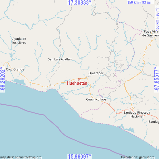
Huehuetán GPS coordinates[2]
16° 38' 8.988" North, 98° 33' 32.004" West
| Map corner | latitude | longitude |
|---|---|---|
| Upper-left | 17.30833°, | -99.26202° |
| Center: | 16.63583°, | -98.55889° |
| Lower-right: | 15.96097°, | -97.85577° |
| Map W x H: | 149.8×149.8 km | = 93.1×93.1mi |
| max Lat: | 32.7° ⇑93.4% North |
| Huehuetán: | 16.63583° |
| min Lat: | ⇓6.6% South 14.53588° |
| min Long | Huehuetán | max Long |
| -117.105° | -98.55889° | -86.73105° |
| W 56.5%⇐ | ⇒43.5% E |
Elevation
Elevation of Huehuetán is 201 m = 659 ft, and this is 1052.7 m = 3454 ft below average elevation for this country.
| Max E: |
3497 m = 11473 ft | 75.6% |
| Avg. | 1253.7 m = 4113 ft | |
| Huehuetán | 201 m = 659 ft | |
Min E: |
-1 m = -3 ft | 24.4% |
See also: Mexico elevation on elevation.city.
Geographical zone
Huehuetán is located in North Torrid zone (between Equator and Tropic of Cancer). Distance of this Northern Tropic circle is 756.2 km =469.9 mi to North.| Distance of | km | miles | from Huehuetán |
|---|---|---|---|
| North Pole | 8157.3 | 5068.7 | to North |
| Arctic Circle | 5551.4 | 3449.5 | to North |
| Tropic Cancer | 756.2 | 469.9 | to North |
| Equator | 1849.7 | 1149.3 | to South |


Nearby cities:
15 places around Huehuetán: (largest is in red/bold)
• Arcelia de Rodríguez
14.5 km =9 mi,  320°
320°
• Azoyú
11.7 km =7.3 mi,  337°
337°
• Cerro del Indio (El Indio)
13.7 km =8.5 mi,  146°
146°
• Colonia Miguel Alemán Valdez
11.7 km =7.3 mi,  162°
162°
• Comaltepec
11.2 km =7 mi,  123°
123°
• Cruz de Corazón
14 km =8.7 mi,  62°
62°
• El Pitahayo
12 km =7.5 mi, 163°
• Igualapa
15 km =9.3 mi,  35°
35°
• Juchitán
8.8 km =5.5 mi,  261°
261°
• Las Vigas
11.9 km =7.4 mi,  67°
67°
• Milpillas
12.1 km =7.5 mi, 119°
• San Isidro el Puente (El Puente)
7.6 km =4.7 mi,  286°
286°
• San Juan de los Llanos
6.7 km =4.2 mi, 70°
• Tenango
4.3 km =2.7 mi, 38°
• Zapotitlán de la Fuente (El Zapote)
12.3 km =7.6 mi,  326°
326°
Sources, notices
• [Note1] Compared only with cities in Mexico existing in our database
• [Src1] Map data: © OpenStreetMap contributors (CC-BY-SA)
• [Src2] Other city data from geonames.org with taken over terms of usage.
• [Src3] Geographical zone / Annual Mean Temperature by Robert A. Rohde @ Wikipedia
