Yaxhachen geodata
Yaxhachen (Yucatán) is a populated place; located in Mexico in America/Merida (GMT-6) time zone. With population of 1,633 people, there are 5302 cities with bigger population in this country. Compared to other cities in Mexico, 58% of cities are located further ↓South; 98% of cities are located further ←West and 79% of cities have higher elevation than Yaxhachen. Note1


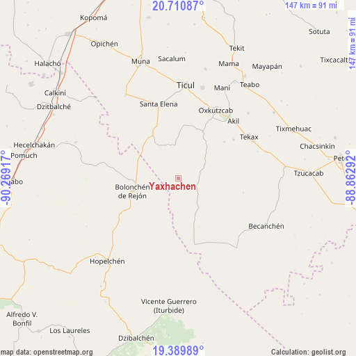
Yaxhachen GPS coordinates[2]
20° 3' 6.372" North, 89° 33' 57.744" West
| Map corner | latitude | longitude |
|---|---|---|
| Upper-left | 20.71087°, | -90.26917° |
| Center: | 20.05177°, | -89.56604° |
| Lower-right: | 19.38989°, | -88.86292° |
| Map W x H: | 146.9×146.9 km | = 91.3×91.3mi |
| max Lat: | 32.7° ⇑42% North |
| Yaxhachen: | 20.05177° |
| min Lat: | ⇓58% South 14.53588° |
| min Long | Yaxhachen | max Long |
| -117.105° | -89.56604° | -86.73105° |
| W 98%⇐ | ⇒2% E |
Elevation
Elevation of Yaxhachen is 111 m = 364 ft, and this is 1142.7 m = 3749 ft below average elevation for this country.
| Max E: |
3497 m = 11473 ft | 79% |
| Avg. | 1253.7 m = 4113 ft | |
| Yaxhachen | 111 m = 364 ft | |
Min E: |
-1 m = -3 ft | 21% |
See also: Mexico elevation on elevation.city.
Geographical zone
Yaxhachen is located in North Torrid zone (between Equator and Tropic of Cancer). Distance of this Northern Tropic circle is 376.4 km =233.9 mi to North.| Distance of | km | miles | from Yaxhachen |
|---|---|---|---|
| North Pole | 7777.5 | 4832.7 | to North |
| Arctic Circle | 5171.6 | 3213.5 | to North |
| Tropic Cancer | 376.4 | 233.9 | to North |
| Equator | 2229.5 | 1385.3 | to South |


Nearby cities:
15 places around Yaxhachen: (largest is in red/bold)
• Akil
32.9 km =20.4 mi,  43°
43°
• Bolonchén de Rejón
19.6 km =12.2 mi,  254°
254°
• Dzan
38.8 km =24.1 mi,  15°
15°
• Emiliano Zapata
21.9 km =13.6 mi,  27°
27°
• Kancab
28 km =17.4 mi,  55°
55°
• Nahalal
36 km =22.4 mi,  279°
279°
• Oxkutzkab
32.3 km =20.1 mi, 28°
• Pustunich
35.7 km =22.2 mi,  9°
9°
• Santa Elena
31.9 km =19.8 mi,  345°
345°
• Tecax
33.9 km =21.1 mi, 59°
• Ticul
38.7 km =24 mi,  4°
4°
• Ticum
38 km =23.6 mi,  73°
73°
• Xohuayan
24.4 km =15.2 mi,  51°
51°
• Xul
12.1 km =7.5 mi, 62°
• Yotholin
32.8 km =20.4 mi, 20°
Sources, notices
• [Note1] Compared only with cities in Mexico existing in our database
• [Src1] Map data: © OpenStreetMap contributors (CC-BY-SA)
• [Src2] Other city data from geonames.org with taken over terms of usage.
• [Src3] Geographical zone / Annual Mean Temperature by Robert A. Rohde @ Wikipedia
