La Reforma geodata
La Reforma (Veracruz) is a populated place; located in Mexico in America/Mexico_City (GMT-6) time zone. With population of 1,389 people, there are 6229 cities with bigger population in this country. Compared to other cities in Mexico, 51.9% of cities are located further ↑North; 78.9% of cities are located further ←West and 65% of cities have higher elevation than La Reforma. Note1


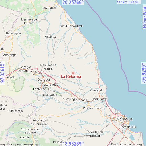
La Reforma GPS coordinates[2]
19° 35' 47.904" North, 96° 37' 58.872" West
| Map corner | latitude | longitude |
|---|---|---|
| Upper-left | 20.25766°, | -97.33615° |
| Center: | 19.59664°, | -96.63302° |
| Lower-right: | 18.93289°, | -95.9299° |
| Map W x H: | 147.3×147.3 km | = 91.5×91.5mi |
| max Lat: | 32.7° ⇑51.9% North |
| La Reforma: | 19.59664° |
| min Lat: | ⇓48.1% South 14.53588° |
| min Long | La Reforma | max Long |
| -117.105° | -96.63302° | -86.73105° |
| W 78.9%⇐ | ⇒21.1% E |
Elevation
Elevation of La Reforma is 684 m = 2244 ft, and this is 569.7 m = 1869 ft below average elevation for this country.
| Max E: |
3497 m = 11473 ft | 65% |
| Avg. | 1253.7 m = 4113 ft | |
| La Reforma | 684 m = 2244 ft | |
Min E: |
-1 m = -3 ft | 35% |
See also: Mexico elevation on elevation.city.
Geographical zone
La Reforma is located in North Torrid zone (between Equator and Tropic of Cancer). Distance of this Northern Tropic circle is 427 km =265.3 mi to North.| Distance of | km | miles | from La Reforma |
|---|---|---|---|
| North Pole | 7828.1 | 4864.2 | to North |
| Arctic Circle | 5222.2 | 3244.9 | to North |
| Tropic Cancer | 427 | 265.3 | to North |
| Equator | 2178.9 | 1353.9 | to South |


Nearby cities:
15 places around La Reforma: (largest is in red/bold)
• Actopan
10.4 km =6.5 mi,  170°
170°
• Alto Lucero
11 km =6.8 mi,  286°
286°
• Blanca Espuma
6 km =3.7 mi,  253°
253°
• Cerrillos de Diaz
10.3 km =6.4 mi, 290°
• Cerro Gordo
3.4 km =2.1 mi,  208°
208°
• Chicuasen
8.7 km =5.4 mi, 208°
• El Cafetal
12.5 km =7.8 mi,  321°
321°
• Flor Blanca
7.3 km =4.5 mi, 166°
• Mesa de Guadalupe
7.8 km =4.8 mi,  242°
242°
• Otates
12.1 km =7.5 mi,  225°
225°
• Ranchito de las Ánimas
8.6 km =5.3 mi,  191°
191°
• San José Pastorías
7.5 km =4.7 mi,  118°
118°
• Trapiche del Rosario
12.8 km =8 mi, 242°
• Villa Nueva
9.5 km =5.9 mi,  199°
199°
• Zoyacuautla
6.2 km =3.9 mi,  110°
110°
Sources, notices
• [Note1] Compared only with cities in Mexico existing in our database
• [Src1] Map data: © OpenStreetMap contributors (CC-BY-SA)
• [Src2] Other city data from geonames.org with taken over terms of usage.
• [Src3] Geographical zone / Annual Mean Temperature by Robert A. Rohde @ Wikipedia
