Alto Lucero geodata
Alto Lucero (Veracruz) is a seat of a second-order administrative division; located in Mexico in America/Mexico_City (GMT-6) time zone. With population of 4,693 people, there are 1966 cities with bigger population in this country. Compared to other cities in Mexico, 51.4% of cities are located further ↑North; 78% of cities are located further ←West and 57.1% of cities have higher elevation than Alto Lucero. Note1


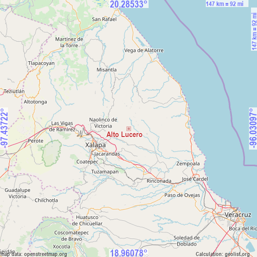
Alto Lucero GPS coordinates[2]
19° 37' 27.912" North, 96° 44' 2.724" West
| Map corner | latitude | longitude |
|---|---|---|
| Upper-left | 20.28533°, | -97.43722° |
| Center: | 19.62442°, | -96.73409° |
| Lower-right: | 18.96078°, | -96.03097° |
| Map W x H: | 147.3×147.3 km | = 91.5×91.5mi |
| max Lat: | 32.7° ⇑51.4% North |
| Alto Lucero: | 19.62442° |
| min Lat: | ⇓48.6% South 14.53588° |
| min Long | Alto Lucero | max Long |
| -117.105° | -96.73409° | -86.73105° |
| W 78%⇐ | ⇒22% E |
Elevation
Elevation of Alto Lucero is 1119 m = 3671 ft, and this is 134.7 m = 442 ft below average elevation for this country.
| Max E: |
3497 m = 11473 ft | 57.1% |
| Avg. | 1253.7 m = 4113 ft | |
| Alto Lucero | 1119 m = 3671 ft | |
Min E: |
-1 m = -3 ft | 42.9% |
See also: Mexico elevation on elevation.city.
Geographical zone
Alto Lucero is located in North Torrid zone (between Equator and Tropic of Cancer). Distance of this Northern Tropic circle is 423.9 km =263.4 mi to North.| Distance of | km | miles | from Alto Lucero |
|---|---|---|---|
| North Pole | 7825 | 4862.2 | to North |
| Arctic Circle | 5219.1 | 3243 | to North |
| Tropic Cancer | 423.9 | 263.4 | to North |
| Equator | 2182 | 1355.8 | to South |


Nearby cities:
15 places around Alto Lucero: (largest is in red/bold)
• Almolonga
6.4 km =4 mi,  233°
233°
• Blanca Espuma
6.8 km =4.2 mi,  135°
135°
• Cerrillos de Diaz
1.1 km =0.7 mi,  61°
61°
• Cerro Gordo
10.9 km =6.8 mi,  124°
124°
• El Cafetal
7.3 km =4.5 mi,  22°
22°
• Enríquez
6.2 km =3.9 mi,  350°
350°
• Las Haldas
9.5 km =5.9 mi,  272°
272°
• Mafafas
4.4 km =2.7 mi,  329°
329°
• Mesa de Guadalupe
7.6 km =4.7 mi,  151°
151°
• Monte Verde Chivería
9.6 km =6 mi, 24°
• San Nicolás
8.4 km =5.2 mi,  205°
205°
• Tepetlán
8.6 km =5.3 mi,  309°
309°
• Trapiche del Rosario
9.1 km =5.7 mi,  184°
184°
• Vicente Guerrero (Tepetates)
7.8 km =4.8 mi,  258°
258°
• Xomotla
6 km =3.7 mi,  10°
10°
Sources, notices
• [Note1] Compared only with cities in Mexico existing in our database
• [Src1] Map data: © OpenStreetMap contributors (CC-BY-SA)
• [Src2] Other city data from geonames.org with taken over terms of usage.
• [Src3] Geographical zone / Annual Mean Temperature by Robert A. Rohde @ Wikipedia
