Otates geodata
Otates (Veracruz) is a populated place; located in Mexico in America/Mexico_City (GMT-6) time zone. With population of 1,136 people, there are 7638 cities with bigger population in this country. Compared to other cities in Mexico, 53.6% of cities are located further ↑North; 78.3% of cities are located further ←West and 68.1% of cities have higher elevation than Otates. Note1


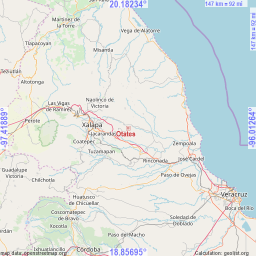
Otates GPS coordinates[2]
19° 31' 15.6" North, 96° 42' 56.736" West
| Map corner | latitude | longitude |
|---|---|---|
| Upper-left | 20.18234°, | -97.41889° |
| Center: | 19.521°, | -96.71576° |
| Lower-right: | 18.85695°, | -96.01264° |
| Map W x H: | 147.4×147.4 km | = 91.6×91.6mi |
| max Lat: | 32.7° ⇑53.6% North |
| Otates: | 19.521° |
| min Lat: | ⇓46.4% South 14.53588° |
| min Long | Otates | max Long |
| -117.105° | -96.71576° | -86.73105° |
| W 78.3%⇐ | ⇒21.7% E |
Elevation
Elevation of Otates is 528 m = 1732 ft, and this is 725.7 m = 2381 ft below average elevation for this country.
| Max E: |
3497 m = 11473 ft | 68.1% |
| Avg. | 1253.7 m = 4113 ft | |
| Otates | 528 m = 1732 ft | |
Min E: |
-1 m = -3 ft | 31.9% |
See also: Mexico elevation on elevation.city.
Geographical zone
Otates is located in North Torrid zone (between Equator and Tropic of Cancer). Distance of this Northern Tropic circle is 435.4 km =270.5 mi to North.| Distance of | km | miles | from Otates |
|---|---|---|---|
| North Pole | 7836.5 | 4869.4 | to North |
| Arctic Circle | 5230.6 | 3250.1 | to North |
| Tropic Cancer | 435.4 | 270.5 | to North |
| Equator | 2170.5 | 1348.7 | to South |


Nearby cities:
15 places around Otates: (largest is in red/bold)
• Blanca Espuma
7.3 km =4.5 mi,  23°
23°
• Cerro Gordo
8.9 km =5.5 mi,  52°
52°
• Cerro Gordo
9.9 km =6.2 mi,  170°
170°
• Chicuasen
4.6 km =2.9 mi,  80°
80°
• Dos Ríos
9.7 km =6 mi,  244°
244°
• El Terrero
8.9 km =5.5 mi,  281°
281°
• Flor Blanca
10.5 km =6.5 mi, 82°
• La Tinaja
4.2 km =2.6 mi,  262°
262°
• Lomas de Miradores
10 km =6.2 mi,  227°
227°
• Mesa de Guadalupe
5.1 km =3.2 mi, 19°
• Pinoltepec
9.7 km =6 mi,  205°
205°
• Ranchito de las Ánimas
7 km =4.3 mi,  90°
90°
• San Nicolás
6.8 km =4.2 mi,  304°
304°
• Trapiche del Rosario
3.6 km =2.2 mi,  312°
312°
• Villa Nueva
5.5 km =3.4 mi,  95°
95°
Sources, notices
• [Note1] Compared only with cities in Mexico existing in our database
• [Src1] Map data: © OpenStreetMap contributors (CC-BY-SA)
• [Src2] Other city data from geonames.org with taken over terms of usage.
• [Src3] Geographical zone / Annual Mean Temperature by Robert A. Rohde @ Wikipedia
