Actopan geodata
Actopan (Veracruz) is a seat of a second-order administrative division; located in Mexico in America/Mexico_City (GMT-6) time zone. With population of 4,102 people, there are 2229 cities with bigger population in this country. Compared to other cities in Mexico, 53.9% of cities are located further ↑North; 79% of cities are located further ←West and 74% of cities have higher elevation than Actopan. Note1


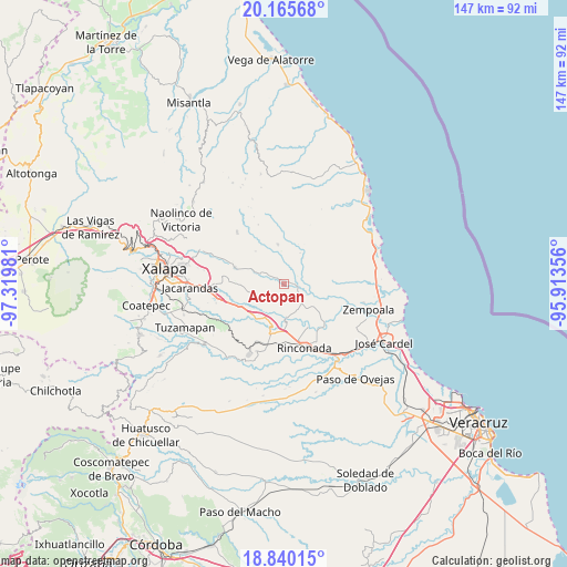
Actopan GPS coordinates[2]
19° 30' 15.372" North, 96° 37' 0.048" West
| Map corner | latitude | longitude |
|---|---|---|
| Upper-left | 20.16568°, | -97.31981° |
| Center: | 19.50427°, | -96.61668° |
| Lower-right: | 18.84015°, | -95.91356° |
| Map W x H: | 147.4×147.4 km | = 91.6×91.6mi |
| max Lat: | 32.7° ⇑53.9% North |
| Actopan: | 19.50427° |
| min Lat: | ⇓46.1% South 14.53588° |
| min Long | Actopan | max Long |
| -117.105° | -96.61668° | -86.73105° |
| W 79%⇐ | ⇒21% E |
Elevation
Elevation of Actopan is 254 m = 833 ft, and this is 999.7 m = 3280 ft below average elevation for this country.
| Max E: |
3497 m = 11473 ft | 74% |
| Avg. | 1253.7 m = 4113 ft | |
| Actopan | 254 m = 833 ft | |
Min E: |
-1 m = -3 ft | 26% |
See also: Mexico elevation on elevation.city.
Geographical zone
Actopan is located in North Torrid zone (between Equator and Tropic of Cancer). Distance of this Northern Tropic circle is 437.2 km =271.7 mi to North.| Distance of | km | miles | from Actopan |
|---|---|---|---|
| North Pole | 7838.4 | 4870.6 | to North |
| Arctic Circle | 5232.5 | 3251.3 | to North |
| Tropic Cancer | 437.2 | 271.7 | to North |
| Equator | 2168.7 | 1347.6 | to South |


Nearby cities:
15 places around Actopan: (largest is in red/bold)
• Blanca Espuma
11.4 km =7.1 mi,  318°
318°
• Cerro Gordo
8 km =5 mi,  335°
335°
• Cerro Gordo
11.8 km =7.3 mi,  228°
228°
• Chicuasen
6.4 km =4 mi,  294°
294°
• El Aguaje
9.7 km =6 mi,  179°
179°
• Flor Blanca
3.2 km =2 mi,  0°
0°
• La Esperanza
6.5 km =4 mi,  115°
115°
• La Reforma
10.4 km =6.5 mi,  350°
350°
• Mesa de Guadalupe
10.9 km =6.8 mi,  307°
307°
• Otates
10.5 km =6.5 mi,  280°
280°
• Paso de la Milpa
8.6 km =5.3 mi, 177°
• Ranchito de las Ánimas
3.9 km =2.4 mi,  298°
298°
• San José Pastorías
8.2 km =5.1 mi,  35°
35°
• Villa Nueva
5.1 km =3.2 mi, 285°
• Zoyacuautla
9 km =5.6 mi,  27°
27°
Sources, notices
• [Note1] Compared only with cities in Mexico existing in our database
• [Src1] Map data: © OpenStreetMap contributors (CC-BY-SA)
• [Src2] Other city data from geonames.org with taken over terms of usage.
• [Src3] Geographical zone / Annual Mean Temperature by Robert A. Rohde @ Wikipedia
