Tigrillos geodata
Tigrillos (Veracruz) is a populated place; located in Mexico in America/Mexico_City (GMT-6) time zone. With population of 670 people, there are 12949 cities with bigger population in this country. Compared to other cities in Mexico, 57.1% of cities are located further ↑North; 78.5% of cities are located further ←West and 68.7% of cities have higher elevation than Tigrillos. Note1


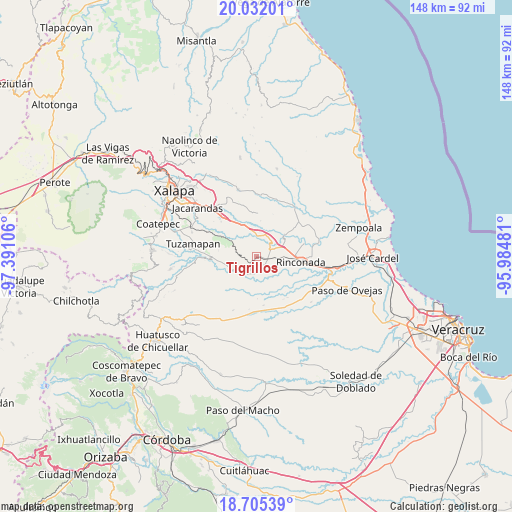
Tigrillos GPS coordinates[2]
19° 22' 12.18" North, 96° 41' 16.548" West
| Map corner | latitude | longitude |
|---|---|---|
| Upper-left | 20.03201°, | -97.39106° |
| Center: | 19.37005°, | -96.68793° |
| Lower-right: | 18.70539°, | -95.98481° |
| Map W x H: | 147.5×147.5 km | = 91.7×91.7mi |
| max Lat: | 32.7° ⇑57.1% North |
| Tigrillos: | 19.37005° |
| min Lat: | ⇓42.9% South 14.53588° |
| min Long | Tigrillos | max Long |
| -117.105° | -96.68793° | -86.73105° |
| W 78.5%⇐ | ⇒21.5% E |
Elevation
Elevation of Tigrillos is 487 m = 1598 ft, and this is 766.7 m = 2515 ft below average elevation for this country.
| Max E: |
3497 m = 11473 ft | 68.7% |
| Avg. | 1253.7 m = 4113 ft | |
| Tigrillos | 487 m = 1598 ft | |
Min E: |
-1 m = -3 ft | 31.3% |
See also: Mexico elevation on elevation.city.
Geographical zone
Tigrillos is located in North Torrid zone (between Equator and Tropic of Cancer). Distance of this Northern Tropic circle is 452.2 km =281 mi to North.| Distance of | km | miles | from Tigrillos |
|---|---|---|---|
| North Pole | 7853.3 | 4879.8 | to North |
| Arctic Circle | 5247.4 | 3260.6 | to North |
| Tropic Cancer | 452.2 | 281 | to North |
| Equator | 2153.7 | 1338.2 | to South |


Nearby cities:
15 places around Tigrillos: (largest is in red/bold)
• Agua Caliente
7.1 km =4.4 mi,  141°
141°
• Apazapan
6.4 km =4 mi,  210°
210°
• Cerro Colorado (Estación Apazapán)
2.8 km =1.7 mi,  226°
226°
• Cerro Gordo
7.2 km =4.5 mi,  349°
349°
• Chahuapan
2.6 km =1.6 mi,  174°
174°
• Chavarrillo
12.8 km =8 mi,  298°
298°
• El Aguaje
9.1 km =5.7 mi,  54°
54°
• El Roble
6.7 km =4.2 mi,  313°
313°
• Jalcomulco
8.9 km =5.5 mi,  241°
241°
• Palo Gacho
5.9 km =3.7 mi,  66°
66°
• Paso de la Milpa
10.1 km =6.3 mi, 50°
• Pinoltepec
10.7 km =6.6 mi,  318°
318°
• Plan del Río
5.1 km =3.2 mi, 46°
• Santa María Tatetla
11.1 km =6.9 mi,  193°
193°
• Villa Emiliano Zapata
3.2 km =2 mi,  102°
102°
Sources, notices
• [Note1] Compared only with cities in Mexico existing in our database
• [Src1] Map data: © OpenStreetMap contributors (CC-BY-SA)
• [Src2] Other city data from geonames.org with taken over terms of usage.
• [Src3] Geographical zone / Annual Mean Temperature by Robert A. Rohde @ Wikipedia
