Pinoltepec geodata
Pinoltepec (Veracruz) is a populated place; located in Mexico in America/Mexico_City (GMT-6) time zone. With population of 706 people, there are 12320 cities with bigger population in this country. Compared to other cities in Mexico, 55.2% of cities are located further ↑North; 77.8% of cities are located further ←West and 63.3% of cities have higher elevation than Pinoltepec. Note1


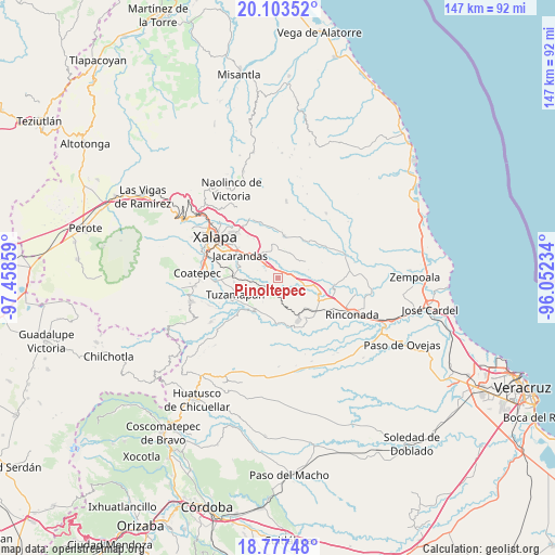
Pinoltepec GPS coordinates[2]
19° 26' 30.66" North, 96° 45' 19.656" West
| Map corner | latitude | longitude |
|---|---|---|
| Upper-left | 20.10352°, | -97.45859° |
| Center: | 19.44185°, | -96.75546° |
| Lower-right: | 18.77748°, | -96.05234° |
| Map W x H: | 147.4×147.4 km | = 91.6×91.6mi |
| max Lat: | 32.7° ⇑55.2% North |
| Pinoltepec: | 19.44185° |
| min Lat: | ⇓44.8% South 14.53588° |
| min Long | Pinoltepec | max Long |
| -117.105° | -96.75546° | -86.73105° |
| W 77.8%⇐ | ⇒22.2% E |
Elevation
Elevation of Pinoltepec is 800 m = 2625 ft, and this is 453.7 m = 1489 ft below average elevation for this country.
| Max E: |
3497 m = 11473 ft | 63.3% |
| Avg. | 1253.7 m = 4113 ft | |
| Pinoltepec | 800 m = 2625 ft | |
Min E: |
-1 m = -3 ft | 36.7% |
See also: Mexico elevation on elevation.city.
Geographical zone
Pinoltepec is located in North Torrid zone (between Equator and Tropic of Cancer). Distance of this Northern Tropic circle is 444.2 km =276 mi to North.| Distance of | km | miles | from Pinoltepec |
|---|---|---|---|
| North Pole | 7845.3 | 4874.8 | to North |
| Arctic Circle | 5239.4 | 3255.6 | to North |
| Tropic Cancer | 444.2 | 276 | to North |
| Equator | 2161.7 | 1343.2 | to South |


Nearby cities:
15 places around Pinoltepec: (largest is in red/bold)
• Cerro Colorado (Estación Apazapán)
11.1 km =6.9 mi,  152°
152°
• Cerro Gordo
5.8 km =3.6 mi,  99°
99°
• Chavarrillo
4.5 km =2.8 mi,  246°
246°
• Dos Ríos
6.6 km =4.1 mi,  315°
315°
• El Chico
8.9 km =5.5 mi,  287°
287°
• El Lencero
8.2 km =5.1 mi,  309°
309°
• El Roble
4 km =2.5 mi, 146°
• Estación Chavarrillo
5.9 km =3.7 mi,  255°
255°
• Estanzuela
11 km =6.8 mi,  281°
281°
• La Tinaja
8.3 km =5.2 mi,  359°
359°
• Lomas de Miradores
3.8 km =2.4 mi,  301°
301°
• Otates
9.7 km =6 mi,  25°
25°
• Rancho Viejo
2.8 km =1.7 mi, 276°
• Tigrillos
10.7 km =6.6 mi,  138°
138°
• Trapiche del Rosario
11.4 km =7.1 mi,  7°
7°
Sources, notices
• [Note1] Compared only with cities in Mexico existing in our database
• [Src1] Map data: © OpenStreetMap contributors (CC-BY-SA)
• [Src2] Other city data from geonames.org with taken over terms of usage.
• [Src3] Geographical zone / Annual Mean Temperature by Robert A. Rohde @ Wikipedia
