Cerro Gordo geodata
Cerro Gordo (Veracruz) is a populated place; located in Mexico in America/Mexico_City (GMT-6) time zone. With population of 1,557 people, there are 5540 cities with bigger population in this country. Compared to other cities in Mexico, 55.4% of cities are located further ↑North; 78.4% of cities are located further ←West and 66.9% of cities have higher elevation than Cerro Gordo. Note1


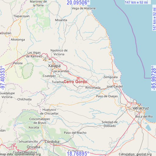
Cerro Gordo GPS coordinates[2]
19° 26' 0.096" North, 96° 42' 1.44" West
| Map corner | latitude | longitude |
|---|---|---|
| Upper-left | 20.09506°, | -97.40353° |
| Center: | 19.43336°, | -96.7004° |
| Lower-right: | 18.76895°, | -95.99728° |
| Map W x H: | 147.4×147.5 km | = 91.6×91.7mi |
| max Lat: | 32.7° ⇑55.4% North |
| Cerro Gordo: | 19.43336° |
| min Lat: | ⇓44.6% South 14.53588° |
| min Long | Cerro Gordo | max Long |
| -117.105° | -96.7004° | -86.73105° |
| W 78.4%⇐ | ⇒21.6% E |
Elevation
Elevation of Cerro Gordo is 590 m = 1936 ft, and this is 663.7 m = 2177 ft below average elevation for this country.
| Max E: |
3497 m = 11473 ft | 66.9% |
| Avg. | 1253.7 m = 4113 ft | |
| Cerro Gordo | 590 m = 1936 ft | |
Min E: |
-1 m = -3 ft | 33.1% |
See also: Mexico elevation on elevation.city.
Geographical zone
Cerro Gordo is located in North Torrid zone (between Equator and Tropic of Cancer). Distance of this Northern Tropic circle is 445.1 km =276.6 mi to North.| Distance of | km | miles | from Cerro Gordo |
|---|---|---|---|
| North Pole | 7846.3 | 4875.5 | to North |
| Arctic Circle | 5240.4 | 3256.2 | to North |
| Tropic Cancer | 445.1 | 276.6 | to North |
| Equator | 2160.8 | 1342.7 | to South |


Nearby cities:
15 places around Cerro Gordo: (largest is in red/bold)
• Cerro Colorado (Estación Apazapán)
9 km =5.6 mi,  184°
184°
• Chahuapan
9.7 km =6 mi,  170°
170°
• Chavarrillo
9.9 km =6.2 mi,  264°
264°
• El Aguaje
9 km =5.6 mi,  101°
101°
• El Roble
4.3 km =2.7 mi,  236°
236°
• Lomas de Miradores
9.5 km =5.9 mi,  288°
288°
• Otates
9.9 km =6.2 mi,  350°
350°
• Palo Gacho
8.2 km =5.1 mi,  125°
125°
• Paso de la Milpa
9.2 km =5.7 mi,  94°
94°
• Pinoltepec
5.8 km =3.6 mi,  279°
279°
• Plan del Río
6.1 km =3.8 mi,  124°
124°
• Rancho Viejo
8.6 km =5.3 mi, 278°
• Tigrillos
7.2 km =4.5 mi, 169°
• Villa Emiliano Zapata
9 km =5.6 mi,  150°
150°
• Villa Nueva
10 km =6.2 mi,  22°
22°
Sources, notices
• [Note1] Compared only with cities in Mexico existing in our database
• [Src1] Map data: © OpenStreetMap contributors (CC-BY-SA)
• [Src2] Other city data from geonames.org with taken over terms of usage.
• [Src3] Geographical zone / Annual Mean Temperature by Robert A. Rohde @ Wikipedia
