Xuchiles geodata
Xuchiles (Veracruz) is a populated place; located in Mexico in America/Mexico_City (GMT-6) time zone. With population of 929 people, there are 9387 cities with bigger population in this country. Compared to other cities in Mexico, 69.3% of cities are located further ↑North; 77% of cities are located further ←West and 69% of cities have higher elevation than Xuchiles. Note1


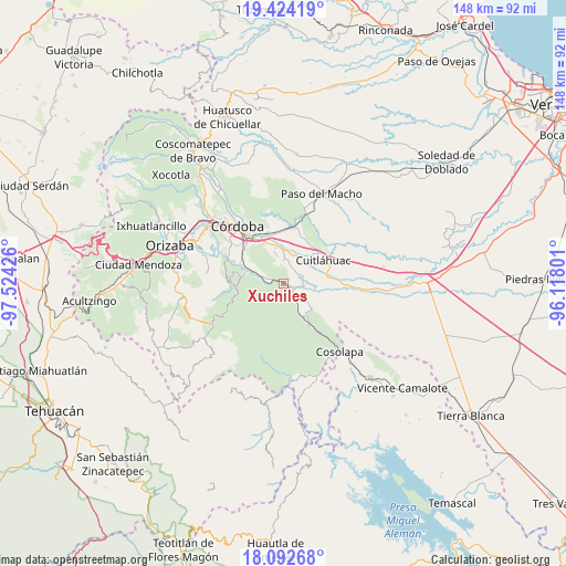
Xuchiles GPS coordinates[2]
18° 45' 35.1" North, 96° 49' 16.068" West
| Map corner | latitude | longitude |
|---|---|---|
| Upper-left | 19.42419°, | -97.52426° |
| Center: | 18.75975°, | -96.82113° |
| Lower-right: | 18.09268°, | -96.11801° |
| Map W x H: | 148.1×148.1 km | = 92×92mi |
| max Lat: | 32.7° ⇑69.3% North |
| Xuchiles: | 18.75975° |
| min Lat: | ⇓30.7% South 14.53588° |
| min Long | Xuchiles | max Long |
| -117.105° | -96.82113° | -86.73105° |
| W 77%⇐ | ⇒23% E |
Elevation
Elevation of Xuchiles is 468 m = 1535 ft, and this is 785.7 m = 2578 ft below average elevation for this country.
| Max E: |
3497 m = 11473 ft | 69% |
| Avg. | 1253.7 m = 4113 ft | |
| Xuchiles | 468 m = 1535 ft | |
Min E: |
-1 m = -3 ft | 31% |
See also: Mexico elevation on elevation.city.
Geographical zone
Xuchiles is located in North Torrid zone (between Equator and Tropic of Cancer). Distance of this Northern Tropic circle is 520 km =323.1 mi to North.| Distance of | km | miles | from Xuchiles |
|---|---|---|---|
| North Pole | 7921.2 | 4922 | to North |
| Arctic Circle | 5315.3 | 3302.8 | to North |
| Tropic Cancer | 520 | 323.1 | to North |
| Equator | 2085.9 | 1296.1 | to South |


Nearby cities:
15 places around Xuchiles: (largest is in red/bold)
• Adolfo López Mateos (San José de Enmedio)
6.6 km =4.1 mi,  28°
28°
• Barrio Guadalupe
6.3 km =3.9 mi,  299°
299°
• Colonia Agrícola Rincón de las Flores
5.3 km =3.3 mi,  211°
211°
• Cuichapa
5.2 km =3.2 mi,  284°
284°
• El Jobo
5.9 km =3.7 mi,  127°
127°
• General Juan José Baz (San José del Corral)
6.9 km =4.3 mi,  2°
2°
• La Loma de Guadalupe
6.1 km =3.8 mi, 0°
• La Providencia
5.3 km =3.3 mi,  98°
98°
• Omealca
4 km =2.5 mi,  110°
110°
• Pocitos
7.4 km =4.6 mi,  151°
151°
• Rincón de Buena Vista
5 km =3.1 mi,  264°
264°
• San José de Abajo
5 km =3.1 mi,  68°
68°
• Tenejápam de Mata
6.5 km =4 mi, 282°
• Tepecoxtla
3.9 km =2.4 mi,  198°
198°
• Xonotla
5 km =3.1 mi,  179°
179°
Sources, notices
• [Note1] Compared only with cities in Mexico existing in our database
• [Src1] Map data: © OpenStreetMap contributors (CC-BY-SA)
• [Src2] Other city data from geonames.org with taken over terms of usage.
• [Src3] Geographical zone / Annual Mean Temperature by Robert A. Rohde @ Wikipedia
