Tenejápam de Mata geodata
Tenejápam de Mata (Veracruz) is a populated place; located in Mexico in America/Mexico_City (GMT-6) time zone. With population of 804 people, there are 10860 cities with bigger population in this country. Compared to other cities in Mexico, 69.1% of cities are located further ↑North; 76.3% of cities are located further ←West and 67.2% of cities have higher elevation than Tenejápam de Mata. Note1


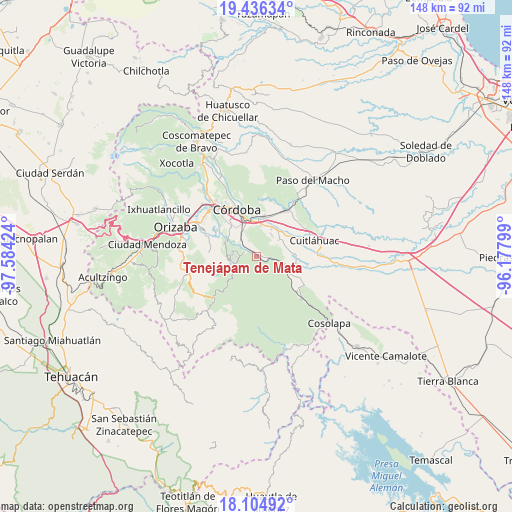
Tenejápam de Mata GPS coordinates[2]
18° 46' 18.984" North, 96° 52' 51.996" West
| Map corner | latitude | longitude |
|---|---|---|
| Upper-left | 19.43634°, | -97.58424° |
| Center: | 18.77194°, | -96.88111° |
| Lower-right: | 18.10492°, | -96.17799° |
| Map W x H: | 148×148 km | = 92×92mi |
| max Lat: | 32.7° ⇑69.1% North |
| Tenejápam de Mata: | 18.77194° |
| min Lat: | ⇓30.9% South 14.53588° |
| min Long | Tenejápam de M | max Long |
| -117.105° | -96.88111° | -86.73105° |
| W 76.3%⇐ | ⇒23.7% E |
Elevation
Elevation of Tenejápam de Mata is 570 m = 1870 ft, and this is 683.7 m = 2243 ft below average elevation for this country.
| Max E: |
3497 m = 11473 ft | 67.2% |
| Avg. | 1253.7 m = 4113 ft | |
| Tenejápam de Mata | 570 m = 1870 ft | |
Min E: |
-1 m = -3 ft | 32.8% |
See also: Mexico elevation on elevation.city.
Geographical zone
Tenejápam de Mata is located in North Torrid zone (between Equator and Tropic of Cancer). Distance of this Northern Tropic circle is 518.7 km =322.3 mi to North.| Distance of | km | miles | from Tenejápam de Mata |
|---|---|---|---|
| North Pole | 7919.8 | 4921.1 | to North |
| Arctic Circle | 5313.9 | 3301.9 | to North |
| Tropic Cancer | 518.7 | 322.3 | to North |
| Equator | 2087.2 | 1296.9 | to South |


Nearby cities:
15 places around Tenejápam de Mata: (largest is in red/bold)
• Barrio Guadalupe
1.9 km =1.2 mi,  25°
25°
• Cacahuatal
7.8 km =4.8 mi, 32°
• Coetzala
4.1 km =2.5 mi,  291°
291°
• Coetzapotitla
5.5 km =3.4 mi,  254°
254°
• Colonia Agrícola Rincón de las Flores
6.9 km =4.3 mi,  149°
149°
• Cotlaixco
7.2 km =4.5 mi,  266°
266°
• Cuichapa
1.3 km =0.8 mi,  92°
92°
• El Otate
3.7 km =2.3 mi,  336°
336°
• Emiliano Zapata
6.5 km =4 mi, 247°
• Guadalupe
6.7 km =4.2 mi,  316°
316°
• La Loma de Guadalupe
7.9 km =4.9 mi,  53°
53°
• Rincón de Buena Vista
2.2 km =1.4 mi,  144°
144°
• San José Independencia
7 km =4.3 mi,  255°
255°
• Tepecoxtla
7.1 km =4.4 mi,  134°
134°
• Xuchiles
6.5 km =4 mi,  102°
102°
Sources, notices
• [Note1] Compared only with cities in Mexico existing in our database
• [Src1] Map data: © OpenStreetMap contributors (CC-BY-SA)
• [Src2] Other city data from geonames.org with taken over terms of usage.
• [Src3] Geographical zone / Annual Mean Temperature by Robert A. Rohde @ Wikipedia
