La Providencia geodata
La Providencia (Veracruz) is a populated place; located in Mexico in America/Mexico_City (GMT-6) time zone. With population of 3,401 people, there are 2673 cities with bigger population in this country. Compared to other cities in Mexico, 69.5% of cities are located further ↑North; 77.7% of cities are located further ←West and 70.3% of cities have higher elevation than La Providencia. Note1


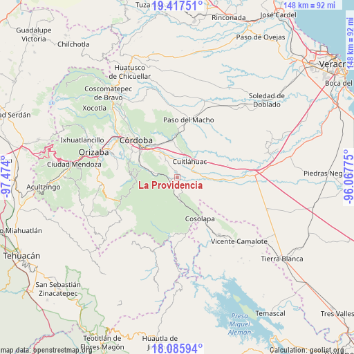
La Providencia GPS coordinates[2]
18° 45' 10.944" North, 96° 46' 15.132" West
| Map corner | latitude | longitude |
|---|---|---|
| Upper-left | 19.41751°, | -97.474° |
| Center: | 18.75304°, | -96.77087° |
| Lower-right: | 18.08594°, | -96.06775° |
| Map W x H: | 148.1×148.1 km | = 92×92mi |
| max Lat: | 32.7° ⇑69.5% North |
| La Providencia: | 18.75304° |
| min Lat: | ⇓30.5% South 14.53588° |
| min Long | La Providencia | max Long |
| -117.105° | -96.77087° | -86.73105° |
| W 77.7%⇐ | ⇒22.3% E |
Elevation
Elevation of La Providencia is 402 m = 1319 ft, and this is 851.7 m = 2794 ft below average elevation for this country.
| Max E: |
3497 m = 11473 ft | 70.3% |
| Avg. | 1253.7 m = 4113 ft | |
| La Providencia | 402 m = 1319 ft | |
Min E: |
-1 m = -3 ft | 29.7% |
See also: Mexico elevation on elevation.city.
Geographical zone
La Providencia is located in North Torrid zone (between Equator and Tropic of Cancer). Distance of this Northern Tropic circle is 520.8 km =323.6 mi to North.| Distance of | km | miles | from La Providencia |
|---|---|---|---|
| North Pole | 7921.9 | 4922.4 | to North |
| Arctic Circle | 5316 | 3303.2 | to North |
| Tropic Cancer | 520.8 | 323.6 | to North |
| Equator | 2085.1 | 1295.6 | to South |


Nearby cities:
15 places around La Providencia: (largest is in red/bold)
• Adolfo López Mateos (San José de Enmedio)
6.9 km =4.3 mi,  341°
341°
• Balsa Larga
4 km =2.5 mi,  170°
170°
• El Jobo
2.9 km =1.8 mi,  192°
192°
• El Tamarindo
7.2 km =4.5 mi,  28°
28°
• Emiliano Zapata
5.8 km =3.6 mi,  145°
145°
• Mata Naranjo
6.6 km =4.1 mi,  65°
65°
• Omealca
1.6 km =1 mi,  247°
247°
• Palmillas
6.9 km =4.3 mi,  359°
359°
• Paso del Rosario
6.6 km =4.1 mi,  108°
108°
• Pocitos
6 km =3.7 mi,  196°
196°
• San José de Abajo
2.6 km =1.6 mi,  345°
345°
• Tepecoxtla
7.2 km =4.5 mi, 246°
• Toluquilla Buena Vista
2.9 km =1.8 mi,  104°
104°
• Xonotla
6.7 km =4.2 mi,  231°
231°
• Xuchiles
5.3 km =3.3 mi,  278°
278°
Sources, notices
• [Note1] Compared only with cities in Mexico existing in our database
• [Src1] Map data: © OpenStreetMap contributors (CC-BY-SA)
• [Src2] Other city data from geonames.org with taken over terms of usage.
• [Src3] Geographical zone / Annual Mean Temperature by Robert A. Rohde @ Wikipedia
