San Fernando geodata
San Fernando (Veracruz) is a populated place; located in Mexico in America/Mexico_City (GMT-6) time zone. With population of 596 people, there are 14429 cities with bigger population in this country. Compared to other cities in Mexico, 74.8% of cities are located further ↓South; 65.2% of cities are located further ←West and 81.8% of cities have higher elevation than San Fernando. Note1


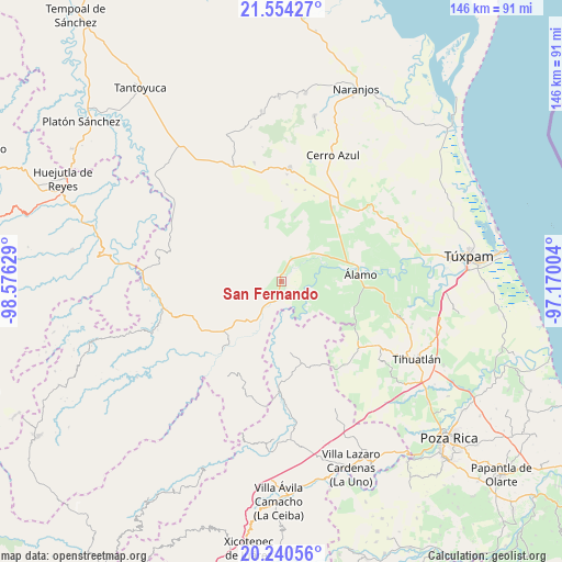
San Fernando GPS coordinates[2]
20° 53' 55.86" North, 97° 52' 23.376" West
| Map corner | latitude | longitude |
|---|---|---|
| Upper-left | 21.55427°, | -98.57629° |
| Center: | 20.89885°, | -97.87316° |
| Lower-right: | 20.24056°, | -97.17004° |
| Map W x H: | 146.1×146.1 km | = 90.8×90.8mi |
| max Lat: | 32.7° ⇑25.2% North |
| San Fernando: | 20.89885° |
| min Lat: | ⇓74.8% South 14.53588° |
| min Long | San Fernando | max Long |
| -117.105° | -97.87316° | -86.73105° |
| W 65.2%⇐ | ⇒34.8% E |
Elevation
Elevation of San Fernando is 72 m = 236 ft, and this is 1181.7 m = 3877 ft below average elevation for this country.
| Max E: |
3497 m = 11473 ft | 81.8% |
| Avg. | 1253.7 m = 4113 ft | |
| San Fernando | 72 m = 236 ft | |
Min E: |
-1 m = -3 ft | 18.2% |
See also: Mexico elevation on elevation.city.
Geographical zone
San Fernando is located in North Torrid zone (between Equator and Tropic of Cancer). Distance of this Northern Tropic circle is 282.2 km =175.4 mi to North.| Distance of | km | miles | from San Fernando |
|---|---|---|---|
| North Pole | 7683.3 | 4774.2 | to North |
| Arctic Circle | 5077.4 | 3154.9 | to North |
| Tropic Cancer | 282.2 | 175.4 | to North |
| Equator | 2323.7 | 1443.9 | to South |


Nearby cities:
15 places around San Fernando: (largest is in red/bold)
• Ayacaxtle
14.7 km =9.1 mi,  300°
300°
• Ayolia
14.3 km =8.9 mi,  238°
238°
• Ejido La Noria
9.1 km =5.7 mi,  62°
62°
• El Mirador
14.5 km =9 mi,  329°
329°
• La Camelia
10.5 km =6.5 mi,  91°
91°
• Las Flores Cinco Poblados
10.4 km =6.5 mi,  68°
68°
• Lomas de Vinazco
4 km =2.5 mi,  193°
193°
• Monte Chiquito
10.4 km =6.5 mi,  46°
46°
• Ojital Santa María
14 km =8.7 mi, 64°
• Palo Blanco
12.4 km =7.7 mi,  81°
81°
• Paso del Perro
10.3 km =6.4 mi,  124°
124°
• Rodríguez Clara
14.8 km =9.2 mi, 94°
• Sombrerete Grande
6.6 km =4.1 mi,  98°
98°
• Tzocohuite
10.9 km =6.8 mi,  213°
213°
• Vegas de la Soledad y Soledad Dos
6.6 km =4.1 mi,  39°
39°
Sources, notices
• [Note1] Compared only with cities in Mexico existing in our database
• [Src1] Map data: © OpenStreetMap contributors (CC-BY-SA)
• [Src2] Other city data from geonames.org with taken over terms of usage.
• [Src3] Geographical zone / Annual Mean Temperature by Robert A. Rohde @ Wikipedia
