Vicente Herrera geodata
Vicente Herrera (Veracruz) is a populated place; located in Mexico in America/Mexico_City (GMT-6) time zone. With population of 1,233 people, there are 7040 cities with bigger population in this country. Compared to other cities in Mexico, 69.5% of cities are located further ↓South; 71.1% of cities are located further ←West and 77.8% of cities have higher elevation than Vicente Herrera. Note1


Vicente Herrera GPS coordinates[2]
20° 34' 37.02" North, 97° 20' 59.028" West
| Map corner | latitude | longitude |
|---|---|---|
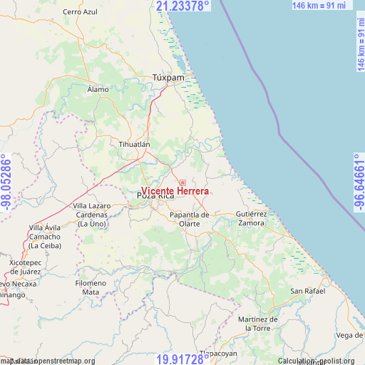
| Upper-left | 21.23378°, | -98.05286° |
| Center: | 20.57695°, | -97.34973° |
| Lower-right: | 19.91728°, | -96.64661° |
| Map W x H: | 146.4×146.4 km | = 91×91mi |
| max Lat: | 32.7° ⇑30.5% North |
| Vicente Herrera: | 20.57695° |
| min Lat: | ⇓69.5% South 14.53588° |
| min Long | Vicente Herrera | max Long |
| -117.105° | -97.34973° | -86.73105° |
| W 71.1%⇐ | ⇒28.9% E |
Elevation
Elevation of Vicente Herrera is 135 m = 443 ft, and this is 1118.7 m = 3670 ft below average elevation for this country.
| Max E: |
3497 m = 11473 ft | 77.8% |
| Avg. | 1253.7 m = 4113 ft | |
| Vicente Herrera | 135 m = 443 ft | |
Min E: |
-1 m = -3 ft | 22.2% |
See also: Mexico elevation on elevation.city.
Geographical zone
Vicente Herrera is located in North Torrid zone (between Equator and Tropic of Cancer). Distance of this Northern Tropic circle is 318 km =197.6 mi to North.| Distance of | km | miles | from Vicente Herrera |
|---|---|---|---|
| North Pole | 7719.1 | 4796.4 | to North |
| Arctic Circle | 5113.2 | 3177.2 | to North |
| Tropic Cancer | 318 | 197.6 | to North |
| Equator | 2287.9 | 1421.6 | to South |


Nearby cities:
15 places around Vicente Herrera: (largest is in red/bold)
• Adolfo Ruíz Cortines
5 km =3.1 mi,  65°
65°
• Arroyo del Maíz Uno
8.2 km =5.1 mi,  236°
236°
• Caristay
8.9 km =5.5 mi,  30°
30°
• Colonia las Arboledas
8 km =5 mi,  281°
281°
• Donato Márquez Azuara
5.9 km =3.7 mi,  194°
194°
• El Cabellal
3.6 km =2.2 mi,  198°
198°
• El Mollejon
7.5 km =4.7 mi, 238°
• Fraccionamiento la Florida
8.3 km =5.2 mi, 277°
• La Grandeza
7.4 km =4.6 mi,  208°
208°
• La Victoria (Kilómetro 47)
7.9 km =4.9 mi,  286°
286°
• Plan de los Mangos
2.3 km =1.4 mi,  143°
143°
• Residencial Tajín
7.4 km =4.6 mi, 288°
• Santa Águeda
4.6 km =2.9 mi,  130°
130°
• Sombrerete
3.1 km =1.9 mi, 30°
• Villa de las Flores
8.7 km =5.4 mi,  269°
269°
Sources, notices
• [Note1] Compared only with cities in Mexico existing in our database
• [Src1] Map data: © OpenStreetMap contributors (CC-BY-SA)
• [Src2] Other city data from geonames.org with taken over terms of usage.
• [Src3] Geographical zone / Annual Mean Temperature by Robert A. Rohde @ Wikipedia
